KBC Home
Tour Table
of Contents
o
Cattle and dairies
o Tulelake Irrigation District (TID) wells/water bank
o Tule Lake historical depth and quantity and evaporation
o Homesteaders
o Canal lining, pros and cons
Bob Davis: In the interest of the schedule and people’s hunger pains, we’re going to get back on the bus and go up the river here just a little ways to a park and have a picnic lunch.
Hartman: But for people other then the people who know this area anyway, you're not going to know the difference. We're going to take you a little bit different way over through my home area. I am Harold Hartman and I am an import to this area. I’ve only been here for 15 years. You have with you some people who represent third and forth generations; you have people who have been here all of there lives. I have not. I have only been here for 15 years, about 12 of which have been involved in water things. I came from a kind of circuitous route to get here to Klamath Falls. I started out, I went all around the world except for Europe, but spent some time in Alaska and spent about eight years back in Nebraska, in Central Nebraska, in a farming operation and some other things. But I started out actually my adult life about 200 miles from here so I kind of ended up back where I am at now. Where that was, was at the mouth of the Eel River in the towns of Eureka and Arcata. When I graduated out of High School I went to Humboldt State.
Cattle and dairies
There is one large dairy that we’ll go by, but
in this Poe Valley here there is a number of large dairies, 500 to 1000 head
dairies probably, so they're not large according to California standards of
course, but they're pretty large around here. You’ll see as we go around the
corner up here and down around here there is a lot of kinds of wetlands and a lot
of wildlife area where the Lost River comes right down through this valley over
here
| Harold Hartman, Project irrigator: This is a fairly large dairy here on our right, and I was just looking to see if he was fertilizing his fields. They have a large, large lagoon right out here to our right and they process that, take all the solids out or most of the solids. And they sprinkle it with these great big, there’s where they’re separating the solids, and they (the sprinklers) have large big guns that cover about 200 ft diameter area, and they are self travelers that move across the field, but I don’t see any of them running right now. |  |
I might talk about another livestock operation here in the basin and that’s the beef cow/calf operation. During the summertime there may be as many as 130 to 150 thousand head and in the wintertime we don’t know for sure. I have a hundred, but there’s maybe 5000 to 10,000 at the most that over-winter here. The rest come in mostly from the south; they over-winter in the California area. If you’re going up north tomorrow I guess you’ll see a lot from the Sprague River area all the way over to the Fort Klamath area where there’s a lot of cattle. It's summertime there. But you get quite a few of them here in the Poe Valley here, a few in the Malin area, the north part of the Malin area, very few down in the Tulelake area, on the eastside there’s some but not a whole lot.
People irrigate here. The Poe Valley is supplied by the Project from the Lost River thru some canals; we just went by some of the canals. This area is also supplied by wells especially up on the hillsides and stuff, and we’ll go by some other places as we go up over the hill here and drop over into Malin that is supplied by wells. So there’s two real sources here.
I drive this virtually everyday, but there are days you can come by and you can see ten poles in a row where you have bald eagles on each one. Occasionally they’ll let some hawks in and stuff, but mostly it’s the bald eagles and stuff. Springtime a lot of times a hard winter or something when calving starts with the eagles, we’ve had eagles come and take a dead calf just right out of the pasture. There is some contention here that the eagles don’t go very far to eat, but we're 25 miles away from the main roost and I guarantee you they fly that far. They really do, but there’s a lot of them in this general area.
Tulelake Irrigation District (TID) wells/water
bank
Crawford: They were terribly expensive. We
thought we would drill about 25 or 30 wells with our 5 million dollars. We
drilled 14 and that was all. But several of them are the highest production
wells that exist in the state of California. When we fire up it takes a lot of
electricity, but we can pump 78 thousand gallons a minute out of those 14 wells.
To give you an idea about how insignificant that is to our irrigation district,
we can supply real time deliveries to 15% of our acres with that 78 thousand
gallons a minute. It cannot stand-alone. It cannot be distributed fairly
or evenly. It has to be done in conjunction with a surface water delivery to be
a viable commodity to us.
We talked some about the water bank. There are 17,000 idle acres in the Project this year, and those idle acres are being paid about 75 dollars per acre foot that they would have used had they’d been in production. At the end of June when we began to realize that there was a problem, that we weren’t going to maintain our lake elevation for suckers, and I have to tell you that in the period of June 25th to the first of July, there was a potential that Upper Klamath Lake was going to drop one inch below that level which was absolutely necessary for sucker survival. Now on July 1st we could drop that lake 5 inches according to the biological opinion. So somebody has to explain to me how the suckers know and why it’s good for them to hold that one inch for five days and then drop the lake 5 inches on the sixth day. That’s the kind of issues that we're trying to struggle through biologically and go away from a stair-step approach with benchmarks and get to some kind of an accelerated curve that allows us the flexibility necessary to operate the Project. It’s going to make more sense for the operation of the Project. But it’s going to make more sense for the resource that we're trying to protect, and that’s just as important as well. In that same time period about June 25th when we realized there was a problem, Tulelake Irrigation was not pumping these wells. They are very expensive. The electricity alone with the preferential power rate is very expensive. There are tremendous amounts of other costs associated with this for the operation and maintenance of the facilities that the water is being pumped into.
We fired up our wells at that time and we ran them until about 2 weeks ago with no compensation whatsoever. The 17,000 acres that were in the water bank got paid 75 dollars an acre foot for the water they saved, the ground that was in ground water replacement by which people denied their surface water usage, and used their ground water to provide irrigation on their own fields, they were paid to the equivalent of 75 dollars an acre foot for the water that they saved. TID alone had a lot of private pumpers that started their wells and started pumping into the facility so that we could do a better job of maintaining the lake elevation that was deemed vital to the suckers, but TID at the 75 dollar an acre foot rate pumped one million dollars worth of water into this system with absolutely no compensation whatsoever. If we are not going to suffer through the third party impact that we suffered through, we’ve got to deal with those third party impacts when we dry up somebody’s domestic well, when we dry up somebody’s irrigation well, we’ve got to be able to deal with those impacts and deal with it in a way that is equitable economically for everybody, and we can’t do that when our neighbors are receiving a subsidy of 75 dollars an acre foot and we're pumping a million dollars worth of water for nothing. That just can’t happen. The same holds true for all those private pumpers who are pumping water out of the goodness of their hearts to maintain lake elevations and to maintain river flows. We have to come up with some way to do that and to deal with third party impacts. To give you an idea of the third party impacts, in 2001 at the end of the season we had four of our wells drilled, and we started pumping on those four wells, and at just about that time that happened in that same time frame, 210 domestic wells right here went dry. We thought goodness, this is a third party impact we may not even be able to deal with. At the same time there was no surface water being delivered to any of the acreage here. Last year we sold some water to the Bureau of Reclamation and, when we fired up the same wells at the same time, no wells went dry. The entirety of those domestic wells were tied to the surface water delivery, not the aquifer that we were pumping the ground water out of. We do have some third party impacts and there are direct ties to about a half a dozen wells that the TID wells interfere with.
I think that perhaps one of the greatest potentials for utilization of the TID wells is to supply refuge water at the time of year that we're not necessarily using those wells for Ag production. We can start about the 15th of September and we can pump some serious volume of water into that refuge if we can work out, first of all, we’ve got to deal with county ground water ordinances that don’t allow the export of ground water from one county to another, and where we co-mingle all this water and it eventually ends up in the Klamath River by the Straits Drain and goes into Del Nord County, we’ve got a little problem there with county ordinances. But I think the permits can be obtained to do as much as that stuff as we wanted to.
Tule Lake historical depth and quantity and
evaporation
One of the things that I wanted to talk to you about as we come into Tulelake
and we're right in the middle of the old lake bed that was Tule Lake: I think
you’ve had a pretty thorough discussion about that this morning and about when
superimposing the Klamath Project over the old lake beds of Tule Lake and Lower
Klamath Lake, what that did to the water supply in the Klamath River. I think
that there is no denying that superimposing the Project on these lands brought
about an increase of flow in the Klamath River. That, tied to the railroad that
cut off all the flow from the Klamath River into the Lower Klamath, the fact
that we used to evaporate between 4 and 6 hundred thousand acre feet of water
annually off of these two huge lakes, and the fact that we use between 3 and 4
hundred thousand of it now agriculturally means that there was a serious net
gain of flow of the Klamath River and I think that any hydrologist would agree
that that is pretty much an irrefutable fact.
Homesteaders
The lands that we’re going to right now were part of the homesteading process
and that was a process that started in the early twenties and continued until
1949, veterans of WWI and WWII, in some cases families that had both. Interestingly enough, a WWI veteran who was awarded a homestead and raised kids
in Tulelake that went off to war in WWII and came back and received a homestead
of their own in the lottery drawing. These people all have pacts signed by, I’ve
seen them signed by, four different Presidents of the United States, that
promised them an adequate supply of water forever. And so how 2001 applies to
those pacts, nobody has ever quite been able to figure that one out. The people
were invited to the land; they had an obligation. They had things that they had
to do, and I think that they have met that obligation every step of the way.
It was a good idea in the early twenties. It’s a good idea now. We’re feeding
the world. We’re doing so in one of the most efficient water delivery systems in
the world.
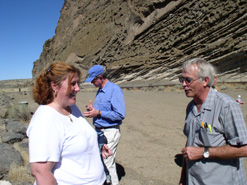
| The mountain at one time was called the Peninsula, but at one time it was a
Peninsula that stuck right out into the Center of Tule Lake. And we’ll stop and
take just a brief look at some ancient writings, the Petroglyphs that exist
there, and you can see watermarks up to, as Bob said, right now as we
go along here, the water in Tule Lake was just about at the top of the power
poles that we see now. That gives you an idea of the magnitude of Tule Lake
itself and how much water potentially evaporated from that lake all the
time.
photo: Denice Helwig, special assistant to HSU President, and Harold Hartman from Malin, OR at the Petroglyphs. Water here was 30' deep before the Project was built. |
 |
And also later in the day we’ll go past the D Plant tunnel that allowed us to become an opened-ended system verses a closed system. These are still called Sump One A and Sump One B, but they indeed are not sumps anymore because, at the end of the day, we pump the water thru the mountain into Lower Klamath thru the Straits Drain back into the Klamath River, about six miles from where it was originally withdrawn so we don’t have a system like the Kesterson System that you’ve heard so much about in California that is a catch all for all of the evils of nature in agriculture at the end of the day. And our water quality tests show that agricultural activities on these lands do virtually no degradation to the quality of that water at all. It's bad, the water quality is terrible, but it is exactly like it is where it is withdrawn from the A Canal at the fish screen that we saw this morning.
And up here on the left as we approach the Peninsula down here you’ll see the old Japanese interment camp that was in Newell California, and interestingly enough, when those homesteaders came from WWII, part of the homesteading deal was that they got half of a prison barracks and those were put on skids and moved with crawler tractors out to each of these homesteads. There wasn’t a paved road anywhere in this system; actually there were very few roads at all. So people drug half of a barracks building out and a lot of them are still living in modified versions of those today. It’s real interesting in our fairgrounds in Tulelake they’ve moved one of those old barracks buildings from Newell and they’ve recreated it as to how it was from pictures of a Japanese internment when a Japanese family was interned there. Half of it is set up that way and the other half is set up the way that the homesteaders improved upon it to make a living quarters for themselves. If you ever have an opportunity to go to the museum at the Tulelake fairgrounds, it’s a very worthwhile thing. They have got one of the old guard towers set up there and it’s really, really very interesting.
Canal lining, pros and cons
Hartman: (Regarding the) open ditch situation like the rest of the Project, we are
presently looking at abandoning some of those open ditches, putting some water in
the pipes, and also doing some canal lining. Where we’re going to go to here in
just a minute and John will talk a little more about it, it’s a major project, a
major canal lining project. It is not a plastic
liner so it doesn’t deteriorate quite as much. It’s
an oil type of a flexible type of a liner. One of the problems with some of
these conservation efforts, they may be helpful on an individual site-specific
thing, but one potential problem is the third party impacts and John talked a
little about them. In 2001 when we had no water in any of the ditches, we had a
lot of third party impacts in regards to domestic wells, and up in the Henley
area and north of here a ways there were a number of wells that had problems
because they were in the shallow aquifer.
Crawford: You see the top of the liner sticking out. We’re now saving all
that water and there is virtually no loss except through evaporation. At the
same time, as Harold said, we have to be careful about the thought of going thru
and lining 225 miles of these canals that have homesteads and home sites all
around that are dependent on a shallow water domestic well for their water. And
we found out in 2001 when we dried up these canals, many, many, many of those
wells went dry and that can happen again. At the same time as I spoke to you
earlier about the refuge water supply, when we line these canals, if we line
those that are just marginally losing water, what that does is, it will dry the
drainage ditch that follows alongside that canal which is the ultimate supply of
water for the refuge. So if we were to go in and enclose them all or line them
all, we would virtually eliminate a good portion of the water supply that the
refuge enjoys today. Indeed a great many of the refuge acres cannot be reached
through the AD delivery system in Lower Klamath and must be reached by the D
Plant channel that pumps out of Tule Lake. And at the same time we also have a
surface water obligation in Tule Lake because we have endangered suckers there
to that require a set lake elevation.
________________________________________________
#12 o Refuge