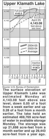
 |
Lakes, rivers
Wednesday, April 27, 2005
Lake levels
|
Clear Lake - Clear Lake's surface elevation was
estimated Monday at 4,522.72 feet above sea level, with storage at 69,040
acre-feet, down 64,830 acre-feet from a year ago.
Gerber Reservoir - The surface elevation of Gerber Reservoir was estimated
Monday at 4,813.35 feet above sea level, with storage at 24,670 acre-feet, down
25,471 acre-feet from a year ago.
River flow
Following are daily averages of the volume of water flowing at key points in the
Klamath Basin, measured in cubic feet per second:
Link River 2005 2004
April 19 1,370 1,335
April 20 1,020 1,155
April 21 1,090 1,295
April 22 1,040 1,187
April 23 838 1,176
April 24 630 1,245
April 25 624 1,179
A Canal
April 19 355 490
April 20 360 495
April 21 375 480
April 22 355 490
April 23 390 538
April 24 375 565
April 25 400 595
Klamath River at Keno Dam
April 19 1,290 1,171
April 20 1,100 1,014
April 21 1,090 1,104
April 22 1,090 1,142
April 23 1,030 1,179
April 24 806 1,182
April 25 802 956
Klamath River at Iron Gate Dam
April 19 1,520 1,759
April 20 1,530 1,751
April 21 1,510 1,711
April 22 1,510 1,711
April 23 1,510 1,703
April 24 1,510 1,711
April 25 1,510 1,695
Net inflow to Upper Klamath Lake
April 19 1,725 1,825
April 20 -183 1,260
April 21 1,075 2,165
April 22 1,395 1,677
April 23 56 1,714
April 24 2,177 2,200
April 25 1,024 1,774
Williamson River
below Sprague R. 2005 Avg.
April 27 580 1,719
Source: U.S. Bureau of Reclamation, U.S. Geological Survey, Oregon Water
Resources Department.
Snow report
Following are today's estimates of the water equivalent measured in inches in
the snowpack at selected sites in Southern Oregon and Northern California.
Site Water Avg. Pct. of
content avg.
Adin Mountain 4.2 7.8 54
Billie Creek Divide 2.9 11.9 24
Cedar Pass 16.1 15.2 106
Chemult Alternate .1 1.4 7
Cold Springs Camp 5.8 22.4 26
Dismal Swamp 30.1 25.7 117
Fourmile Lake 11.5 24.8 46
Sevenmile Marsh 15.9 23.9 67
Strawberry .2 1.2 17
Taylor Butte 1.4 4 350
Klamath Basin pct. of avg. 50
Goose Lake Basin pct. of avg. 100
Source: National Resource Conservation Service