|
Lakes,
rivers
April 13, 2005
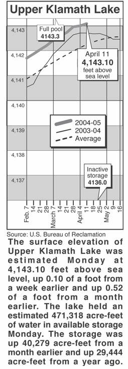
Lake levels
Clear Lake - Clear Lake's
surface elevation was estimated Monday at 4,522.93
feet above sea level, with storage at 72,290
acre-feet, down 60,810 acre-feet from a year ago.
Gerber Reservoir - The surface elevation of Gerber
Reservoir was estimated Monday at 4,812.94 feet
above sea level, with storage at 23,712 acre-feet,
down 26,646 acre-feet from a year ago.
River flow
Following are daily averages of the volume of water
flowing at key points in the Klamath Basin, measured
in cubic feet per second:
Link River 2005 2004
April 5 510 1,637
April 6 476 1,386
April 7 484 1,383
April 8 477 1,381
April 9 474 1,399
April 10 491 1,245
April 11 588 1,241
A Canal
April 5 150 130
April 6 230 210
April 7 210 225
April 8 195 230
April 9 215 235
April 10 215 265
April 11 220 295
Klamath River at Keno Dam
April 5 387 1,431
April 6 383 1,354
April 7 454 1,190
April 8 688 1,188
April 9 706 1,072
April 10 704 988
April 11 699 985
Klamath River at Iron Gate Dam
April 5 1,020 2,001
April 6 1,020 2,010
April 7 1,030 2,019
April 8 1,210 1,925
April 9 1,210 1,792
April 10 1,220 1,776
April 11 1,220 1,776
Net inflow to Upper Klamath Lake
April 5 269 1,767
April 6 -75 1,206
April 7 1,475 1,608
April 8 672 2,001
April 9 3,814 1,244
April 10 706 1,900
April 11 1,199 1,536
Williamson River
below Sprague R. 2005 Avg.
April 13 826 1,729
Source: U.S. Bureau of Reclamation, U.S. Geological
Survey, Oregon Water Resources Department.
Snow report
Following are today's estimates of the water
equivalent measured in inches in the snowpack at
selected sites in Southern Oregon and Northern
California.
Site Water Avg. Pct. of
content avg.
Adin Mountain 10.5 11.0 95
Billie Creek Divide 5.3 17.7 30
Cedar Pass 17.8 18.1 98
Chemult Alternate .1 3.7 3
Cold Springs Camp 8.7 26.1 33
Dismal Swamp 29.4 28.1 105
Fourmile Lake 13.5 28.9 47
Sevenmile Marsh 17.6 28.1 63
Silver Creek 2.5 4.8 52
Strawberry .2 2.8 7
Taylor Butte .9 1.4 64
Klamath Basin pct. of avg. 45
Goose Lake Basin pct. of avg. 92
Source: National Resource Conservation Service
|