Time to Take Action
Our Klamath Basin Water Crisis
Upholding rural Americans' rights to grow food,
own property, and caretake our wildlife and natural resources.
 

Lakes, rivers

 March 16, 2005

Lake levels

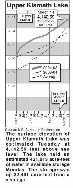
Clear Lake - Clear Lake's surface elevation was estimated Monday at 4,522.59 feet above sea level, with storage at 67,050 acre-feet, down 49,190 acre-feet from a year ago.

Gerber Reservoir - The surface elevation of Gerber Reservoir was estimated Monday at 4,811.47 feet above sea level, with storage at 20,374 acre-feet, down 21,347 acre-feet from a year ago.

River flow

Following are daily averages of the volume of water flowing at key points in the Klamath Basin, measured in cubic feet per second:

Link River 2005 2004

March 9 276 531

March 10 276 575

March 11 275 641

March 12 291 940

March 13 352 892

March 14 350 861

Klamath River at Keno Dam

March 9 316 1,037

March 10 396 991

March 11 488 1,003

March 12 326 1,166

March 13 333 1,204

March 14 330 1,202

Klamath River at Iron Gate Dam

March 9 1,000 2,094

March 10 1,010 2,056

March 11 1,010 2,066

March 12 972 2,056

March 13 839 2,038

March 14 805 2,019

Net inflow to Upper Klamath Lake

March 9 1,447 2,480

March 10 1,446 2,133

March 11 1,055 2,200

March 12 1,462 2,109

March 13 1,523 2,450

March 14 -430 2,030

Williamson River

below Sprague R. 2005 Avg.

March 16 850 1,310

Source: U.S. Bureau of Reclamation, U.S. Geological Survey, Oregon Water Resources Department.

Snow report

Following are today's estimates of the water equivalent measured in inches in the snowpack at selected sites in Southern Oregon and Northern California.

Site Water Avg. Pct. of

content avg.

Adin Mountain 7.4 13.9 53

Billie Creek Divide 2.9 22.4 13

Cedar Pass 13.7 18.0 76

Chemult Alternate .6 7.6 8

Cold Springs Camp 3.3 28.5 12

Diamond Lake 0 14.8 0

Dismal Swamp 21.2 27.0 79

Fourmile Lake 9.1 29.6 31

Quartz Mountain 0 2.0 0

Sevenmile Marsh 9.8 29.3 33

Silver Creek 6.1 9.5 64

Strawberry .1 5.2 2

Taylor Butte 5.5 4.8 115

Klamath Basin pct. of avg. 28

Goose Lake Basin pct. of avg. 67

Source: National Resource Conservation Service


Home

Contact


Page Updated: Thursday May 07, 2009 09:14 AM  Pacific


Copyright © klamathbasincrisis.org, 2005, All Rights Reserved