Lakes, rivers
|
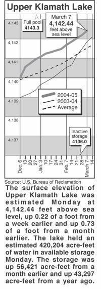
March 9, 2005
Lake levels
Clear Lake - Clear Lake's
surface elevation was estimated Monday at 4,522.94 feet above sea level,
with storage at 72,440 acre-feet, down 30,720 acre-feet from a year ago.
Gerber Reservoir - The surface elevation of Gerber Reservoir was estimated
Monday at 4,811.5 feet above sea level, with storage at 19,586 acre-feet,
down 13,156 acre-feet from a year ago.
River flow
Following are daily averages of the volume of water flowing at key points in
the Klamath Basin, measured in cubic feet per second:
Link River 2005 2004
March 1 323 579
March 2 285 490
March 3 285 484
March 4 281 494
March 5 276 518
March 6 275 813
March 7 277 720
Klamath River at Keno Dam
March 1 481 1,069
March 2 375 962
March 3 375 1,299
March 4 491 1,031
March 5 565 1,007
March 6 561 1,163
March 7 461 1,203
Klamath River at Iron Gate Dam
March 1 860 2,375
March 2 811 2,218
March 3 811 2,160
March 4 850 2,122
March 5 952 2,122
March 6 1,000 2,047
March 7 1,000 2,056
Net inflow to Upper Klamath Lake
March 1 1,102 2,816
March 2 3,013 2,436
March 3 1,455 2,430
March 4 1,452 2,440
March 5 1,836 2,464
March 6 1,055 2,369
March 7 1,448 2,277
Williamson River
below Sprague R. 2005 Avg.
March 8 826 1,190
Source: U.S. Bureau of Reclamation, U.S. Geological Survey, Oregon Water
Resources Department.
Snow report
Following are today's estimates of the water equivalent measured in inches
in the snowpack at selected sites in Southern Oregon and Northern
California.
Site Water Avg. Pct. of
content avg.
Adin Mountain 8.7 13.1 66
Billie Creek Divide 5.6 21.9 26
Cedar Pass 14.1 16.8 84
Chemult Alternate 4.0 7.9 51
Cold Springs Camp 7.4 27.8 27
Dismal Swamp 23.0 25.3 91
Fourmile Lake 10.7 28.3 38
Sevenmile Marsh 10.9 27.9 39
Silver Creek 9.7 9.7 100
Strawberry .2 5.4 2
Taylor Butte 7.6 5.5 138
Klamath Basin pct. of avg. 38
Goose Lake Basin pct. of avg. 78
Source: National Resource Conservation Service