Time to Take Action
Our Klamath Basin Water Crisis
Upholding rural Americans' rights to grow food,
own property, and caretake our wildlife and natural resources.
 

Lakes, rivers

 February 23, 2005

Lake levels

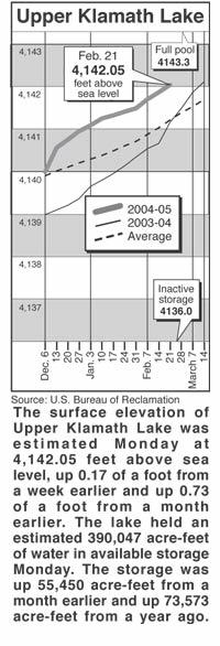
Clear Lake - Clear Lake's surface elevation was estimated Monday at 4,522.67 feet above sea level, with storage at 68,270 acre-feet, down 23,170 acre-feet from a year ago.

Gerber Reservoir - The surface elevation of Gerber Reservoir was estimated Monday at 4,810.48 feet above sea level, with storage at 18,238 acre-feet, down 6,864 acre-feet from a year ago.

River flow

Following are daily averages of the volume of water flowing at key points in the Klamath Basin, measured in cubic feet per second:

Link River 2005 2004

Feb. 15 286 999

Feb. 16 275 573

Feb. 17 273 476

Feb. 18 273 484

Feb. 19 273 488

Feb. 20 272 623

Feb. 21 275 906

Klamath River at Keno Dam

Feb. 15 387 1,214

Feb. 16 383 917

Feb. 17 379 1,252

Feb. 18 377 2,189

Feb. 19 376 2,322

Feb. 20 378 2,027

Feb. 21 526 1,621

Klamath River at Iron Gate Dam

Feb. 15 802 1,312

Feb. 16 799 1,530

Feb. 17 802 2,930

Feb. 18 802 3,918

Feb. 19 804 3,357

Feb. 20 804 3,085

Feb. 21 804 2,941

Net inflow to Upper Klamath Lake

Feb. 15 1,065 1,350

Feb. 16 1,444 2,328

Feb. 17 1,052 5,742

Feb. 18 1,052 3,995

Feb. 19 1,052 3,424

Feb. 20 1,441 2,857

Feb. 21 2,224 2,768

Williamson River

below Sprague R. 2005 Avg.

Feb. 22 735 1,040

Source: U.S. Bureau of Reclamation, U.S. Geological Survey, Oregon Water Resources Department.

Snow report

Following are today's estimates of the water equivalent measured in inches in the snowpack at selected sites in Southern Oregon and Northern California.

Site Water Avg. Pct. of

content avg.

Adin Mountain 8.4 11.3 74

Billie Creek Divide 7.4 20.4 36

Cedar Pass 13.7 14.5 94

Chemult Alternate 6.5 8.0 81

Cold Springs Camp 9.2 25.8 36

Diamond Lake 3.3 14.0 24

Dismal Swamp 22.0 22.2 99

Fourmile Lake 11.1 25.6 43

Quartz Mountain .9 2.4 38

Sevenmile Marsh 11.7 25.2 46

Silver Creek 6.9 9.3 74

Strawberry 2.5 5.5 45

Taylor Butte 8.4 6.0 140

Klamath Basin pct. of avg. 50

Goose Lake Basin pct. of avg. 85

Source: National Resource Conservation Service


Home

Contact


Page Updated: Thursday May 07, 2009 09:14 AM  Pacific


Copyright © klamathbasincrisis.org, 2005, All Rights Reserved