|
http://www.heraldandnews.com/articles/2006/05/01/news/water/water.txt
Klamath
Lakes, Rivers
April 27,2006
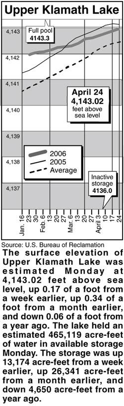
Lake levels
Clear Lake - Clear Lake's
surface elevation was estimated Monday at 4530.83
above sea level, and its storage was 224,120
acre-feet. The lake elevation was up 8.03 of a foot
from a year earlier, and the storage was up 153,850
acre-feet from a year earlier.
Gerber Reservoir - The surface elevation of Gerber
Reservoir was estimated Monday at 4836.46 above sea
level, and its storage was 98,374 acre-feet. The
lake elevation was up 23.21 feet from a year
earlier, and the storage was up 73,939 acre-feet
from a year earlier.
River flow
Following are daily averages of the volume of water
flowing at key points in the Klamath Basin, measured
in cubic feet per second:
Link River 2006 2005
April 18 3,880 1,390
April 19 3,990 1,370
April 20 4,220 1,020
April 21 3,710 1,090
April 22 3,170 1,040
April 23 2,580 838
April 24 2,230 630
Klamath River at A Canal
April 18 195 355
April 19 190 355
April 20 215 360
April 21 255 375
April 22 280 355
April 23 275 390
April 24 275 375
Klamath River at Keno Dam
April 18 5,970 1,580
April 19 5,900 1,290
April 20 5,690 1,100
April 21 4,980 1,090
April 22 4,580 1,090
April 23 4,050 1,030
April 24 3,600 806
Klamath River at Iron Gate Dam
April 18 6,870 1,530
April 19 6,750 1,520
April 20 6,410 1,530
April 21 5,780 1,510
April 22 5,560 1,510
April 23 5,430 1,510
April 24 4,920 1,510
Net inflow to Upper Klamath Lake
April 18 4,856 1,354
April 19 5,352 1,725
April 20 5,216 -183
April 21 5,528 1,075
April 22 6,185 1,395
April 23 3,246 56
April 24 2,505 2,177
Source: U.S. Bureau of Reclamation, U.S. Geological
Survey, Oregon Water Resources Department.
Snow report
Following are today's estimates of the water
equivalent measured in inches in the snowpack at
selected sites in Southern Oregon and Northern
California.
Site Water Avg. Pct. of
content avg.
Sevenmile Marsh 44.7 24.5 182
Cold Springs Camp 45.9 23 200
Fourmile Lake 37 25.4 146
Strawberry 2.2 1.5 147
Quartz Mountain 0 .1
Diamond Lake 14.9 8 186
Billie Creek Divide 31.2 12.8 244
Taylor Butte 7.7 .5
Chemult Alternate M 1.7
Cedar Pass 22.2 15.7 141
Dismal Swamp 50 26.1 192
Adin Mountain 15.8 8.2 193
Silver Creek 17 2.6 654
Klamath Basin pct. of avg. 192
Goose Lake Basin pct. of avg. 198
Source: National Resource Conservation Service |