Our Klamath Basin Water Crisis
Upholding rural Americans' rights to grow food,
own property, and caretake our wildlife and natural resources.
Our Klamath Basin
Water Crisis
Upholding rural Americans' rights to grow food,
own property, and caretake our wildlife and natural resources.
COPCO NO. 1 AND NO.2 From50 Years On The Klamathby John C. Boyle
CO
During the period of 1908 through 1911, the Siskiyou
Electric Power and Light Company had extended its
holdings by acquisition of several smaller power
properties in
In early May 1910 the Siskiyou Electric Power and
Light Company started surveys of Ward's Canyon on
the
The survey headquarters were at William Lennox ranch
where the Ager - Surveys consisted of laying out a triangulation system, bench marks, level lines and contours sufficient to prepare maps which could be used for the purchase of lands and from which volumes of stored water at different elevations could be computed. Also it was necessary to establish on the ground the legal subdivision corners, property lines, fences, roads and buildings. The river bottomlands were covered with beautiful farms used mostly for cattle raising. The homes and buildings were old but generally well kept.
The river meandered
throughout the area, slow flowing and deep until it
reached the canyon, where it became very rapid.
The soil was river silt, some subirrigated and some irrigated from numerous springs, dip wheels and inflow creeks. It would be necessary, if a dam were built at the head of Ward's Canyon to flood practically all of those good farm lands.
The people who lived on
their farms were very reluctant to sell even though
the prices offered were somewhat high, but they
realized that power development was progress and use
of electricity was rapidly becoming a public
necessity.
The principal owners affected were:
William Lennox Mary Ward George L. Chase
Henry Keaton William Raymundo
Maureza Aquada Stone and Edwards
Kitty
Ward Henry and Herman Spannons
Manuel Crovelle
When the reservoir survey was finished,
camp was moved from the
Ward's Canyon, about two miles long, was noted on the County records as unsurveyable. It was lined with bluffs, slides, boulders and inaccessible places. Rattlesnakes were everywhere, and along the river's edge hundreds of beautiful sugar pine logs were left from the river logging days of Klamathon. During May 1911, Ward's camp or camp No.3 on the Klamath River was established to start work on Klamath River dam No. 1. Only a few men were there, living in tents with an old barn for a cookhouse.
The first location
selected for a dam was at the head of Ward's Canyon
where the river broke over into swift water. It was
also the place where Indian Jake (of the Shasta
Indians) used to sit by the hour to spear fish.
The south abutment for a proposed dam looked perfect, but the north abutment looked questionable. Drifts were run with shafts and open cuts as far as 130 feet under ground and perpendicular to the river. The andesite from the south abutment ran nearly across the river then started down at 20 degrees and 40 degrees deeper and deeper. The material on top was talus of cinder, loose volcanic fragments and boulders of basalt. The answer was clear. Any dam at this proposed site for creating a reservoir would be questionable.
Work was discontinued on
Because the proposed project was so close to Fall Creek it was decided to proceed with investigations, layout and design of the project. All this work was done on the job. Foundation investigation and river diversion were started on "Klamath River Dam No. 1" in July 1911, and the prospecting work on another plant below of about the same capacity was started on "Klamath River Dam No.2" at the same time.
For the purpose of
obtaining detailed costs of the work as it
progressed, some 40 sub- divisions into job numbers
were made and an accounting setup on the job. All
bills were paid through the Yreka office, but
payroll payoffs and emergency small expenditures
were made on the job.
Wage Scales
10 hours on the job. Meals $.25: each deducted from
pay. No overtime pay.) May 1911 May 1913
Laborers $2.50 per
day
Patrolmen $65.00 per mo
Drillers $3.00 per
day Power House
Operators $65.00 per mo. Leadmen $3.25 per day Linemen $75.00 per mo. Foremen $4.00 per day Electricians $ 3.50 per day
Boyle-$125.00 per month
& board.
COPCO NO. 1
The area surrounding
the project was a happy hunting ground for the
Indians, plenty of fish in the river and bountiful
wildlife in the lava canyons, especially in
wintertime. Cats and birds of all kinds native to
the country were in abundance on the sunny slopes
between the rim rocks.
Indian "Tom" (a Modoc), and Indian "Jake" (a Shasta)
did the fishing and most of the hunting. They lived
with their squaws on Deer Creek just upstream from
the
Their stories about the caves on the north slope above the railroad switchback where General Grant supposedly corraled the Indians with his cannons and their stories of abuse by the white man were fascinating and unbelievable. Most of the other Indians in the neighborhood were mixed bloods, such as the Keatons, Griffiths, Raymonds, Frains, and others.
Kitty Ward, a
full-blood Indian, lived in a tall log cabin which
she and her white husband Tim built for a home. It
was beautifully located on the lower end of the
proposed reservoir beside flowing springs ample to
irrigate some of the lands.
The cabin was below the flow line so when time to fill the reservoir came, Kitty was told it was necessary for her to move. She certainly knew how to put the white man in his place. Between sobs and tears, she refused again and again to leave her home saying "I no move, let water come, I die here." Tim had been dead for several years, but Andy Marlow, as a ranch foreman and keeper of her wampum cooperated in getting Kitty to visit in Hornbrook, a visit from which she never returned. The area involved is shown on the outline map, Sheet H-53. It was contemplated at the time that the Copco No.1 dam would be constructed to create a reservoir, and that the power- house would be located at the present Copco No.2 site.
As a result of surveys,
it was concluded that development of this project
would produce more power (50,000 KW) than could be
absorbed for a long period of time on the Company's
system. Therefore the development was split into
Copco No.1 and Copco No.2.
The plan adopted for the development of Copco No.1 is shown on the following drawings: Sheets H-54, H-18 and H-91. Foundation investigations, consisting of tunnels, open cuts and diamond drill borings, were started in the fall of 1911 and completed in the spring of 1912. The project is described in an article written by J. C. Boyle for the Journal of Electricity, Power and Gas under date of February 22,1913: Volume XXV, No.8; and in the Yreka Journal, July 9, 1913.
Although the country surrounding the construction
site is principally basalt, and the walls of the
canyon themselves vary to 250 feet in height in
lava, the river in its erosion had exposed a reef
across the canyon at the location of the dam,
approximately 130 feet high. This reef of andesite
was apparently continuous for considerable distance
on both sides of the canyon and considered to be the
oldest exposed formation in the
Geological conditions upstream from the site indicated that at one time the river ran over this reef, 130 feet above its present bed. During the time that the river was at this height the water was backed up approximately 5 miles and formed a natural lake, which varied in width to a mile at the widest part.
It was proposed to fill this gorge made by the river
in eroding the reef, with a concrete dam, and cover
the old original lake bottom with a new artificial
lake. The new lake would have a surface area of 1000
acres and would have a catchment of 77,000
acre-feet. This would be the third lake on the
course of the
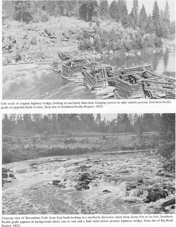
Two of the most interesting construction features of this installation were the diversion of the river from its channel, and the excavation in the river channel for the foundation of the dam. The width of the canyon at the base of the dam was 70 feet, all of which was taken up by the water of the river. For 150 feet above the dam and for 350 feet below the dam, the river channel had a grade of 2 feet per hundred, producing a velocity in the water of about 20 feet per second. The erosion produced by such a current would not permit winging the river from side to side, neither would blasting in the river bottom permit fluming the river, so a wing dam of rock-filled cribs, 30 feet high, was made 100 feet upstream from the main dam.
This wing dam diverted
the river from its original channel through an
unlined tunnel around the east end of the dam. This
tunnel is 356 feet long with a cross section of 16
feet by 18 feet and a grade of 2 feet per hundred.
The dam to be built was of the arch-gravity type, 130 feet in height above the bed of the river, 90 feet thick at the base and 13 feet thick at the top. The length of the crest would be 400 feet, curved on the arc of a circle of 356 feet radius, curvature upstream. The center 200 feet of the crest was to be an overflow section capable of discharging the highest floodwaters. At the upper toe there was a cutoff wall 10 feet thick extending below the foundation of the dam at least 10 feet, and at the lower toe there was provided an apron which would discharge the overflow water in a horizontal direction. Owing to the position of the canyon walls at the dam site, it was found impossible to place the structure perpendicular to the river bed, the west abutment being further down- stream than the east abutment. However, by making the dam curved with a 356-foot radius the ends were found to strike the canyon walls nearly perpendicularly. The total yardage of the dam was about 35,000, of which between 40 and 50 per cent was laid stones. To reinforce the dam on the bottom and on the upstream side, and to facilitate in handling forms, 30-pound railroad rails were imbedded in the concrete. These were spaced 4 feet centers, 4 feet from the face of the concrete and laced together horizontally both across the dam and through the dam. The powerhouse was to be of reinforced concrete with floor dimensions 70 feet by 170 feet and would eventually contain four complete hydroelectric units with exciters, switch- boards and transformers. Each unit was made up of a 12,500 KVA, 10,000 KW at 80 per cent power factor, 200 RPM, 2300 volts, generator weighing 325,470 pounds, connected with an 18,600 HP cylindrical type hydraulic turbine of 84 per cent efficiency, 20 per cent speed rise, 200 RPM, weighing 400,000 pounds and governed by an a.c. oil pressure type, fly-ball governor of 75,000 feet pounds capacity. In October 1912 excavation was started in the river bottom and 24 Diamond drill holes were drilled from shafts on the two sides of the river. These holes intersected at elevation minus 60, which was 130 feet below water surface of the river at the dam site, indicating a foundation for the dam would result in a dam 260 feet high. A wedge-shaped section of gravel and sand filled the river bottom about 81 feet wide at water surface, averaging about 40 feet wide, and about 200 feet up- and down-stream. This wedge was removed by sinking 6' x 12"-2 compartment shafts, using old-time mining techniques and filling these shafts with concrete until a wall was completed across the upstream face of the dam and also the downstream toe of the dam. The material between those walls was removed as an open pit and filled with concrete. When river bottom was reached, a hard continuous andesite was found with no faults or seams. It was smooth as though it had been polished by falling water and on its surface was a layer up to 4 inches deep of fine white marine shells. These looked like snail shells and ranged from pinhead size to that of a wheat kernel. The river bottom was 10 feet narrower and 10 feet higher in elevation at the downstream toe of the dam creating a perfect wedge as an additional safety factor against shear and sliding.
On the west abutment
during the excavation in the river bottom for the
upstream cut-off wall, a pothole was found. This
pothole was about 10 feet in diameter, with a rim on
the river side about 15 feet high and bottom
elevation about plus 10 feet. It contained coarse
sand and round pebbles, which were the remains of
basalt boulders, which had churned out the hole by
constant movement by water. In the bottom of the
hole was found the skull and bones of an extinct
bison, so classified by the
The horns were part of the bone structure connected to the skull and were covered with a layer of smooth substance (ivory) which slaked and fell off immediately upon drying. (July 11, 1914.) The bottom of this pothole also contained a layer of fine marine shells similar to those found on the bedrock at the bottom of the dam. Practically all the work done during the two years from June 1913 to June 1915 was in the foundation of the dam. While the work progressed very satisfactorily, it was slow on account of the reduced force of men. The average number of men working during the two-year period was 27. A pressure grouting system was developed on the job, which aided greatly in excavation of loose gravel in the river bottoms.
Yreka (Siskiyou News).
"The project is a big undertaking and it is difficult to get enough concrete and other, material needed in continuous quantities and is also difficult to transport the needed articles to the scene of the work.
“Representatives of the
company deny the report there is any defect in the
formation which would make the dam unsafe. They say
as soon as material arrives work on the dam will be
rushed." On
However, a contract provided that the S.E.P&. L. Co. should continue to completion the work in progress. Bonds and preferred and common stocks were sold by Copco to provide construction money. On February 2, 1916 the Yreka Journal said: "In order to secure funds for needed construction work, the completion of the great power project at Copco, on the Klamath River, ...the stockholders of the California-Oregon Power Company have assessed themselves $3.30 a share on the outstanding stock, while the bondholders have cooperated by waiving interest on bonds outstanding for five years. This method of financing construction work was deemed preferable to a new bond issue, which would increase interest charges on the company.
" A committee of
bondholders has the power to make a settlement with
the company, either for cash or stock covering
interest in default. In addition to bonds deposited
to secure borrowed money, there are $3,200,000.00
first and refunding bonds outstanding.
"The company is paying interest on $1,200,000.00
underlying bonds and on its floating debt and is
earning enough to pay upon the first and refunding
bonds, but necessary construction is underway for
which the money is needed. "These financial
arrangements have been accompanied by a
reorganization of the company, with some of the
strongest financiers in
This marked the passing of control from Churchill to
the McKee interests. The Churchills,
In May 1910, river gauging was begun at the Ward's bridge and records of river discharges were kept daily. A study of the records over a period of five years indicated a change from a uniform flowing stream to one with lower water in summer and higher water in early spring. Answer to the change was readily found in the development of the reclamation and irrigation project being constructed by the U. S. Reclamation Service in the Upper Klamath basin. While the change in river flows were not too serious at the time, they were destined to get worse as the Reclamation Service projects progressed.
The Company had already invested large sums of money
on Klamath River Dam No. 1 and No.2, so it was faced
with either bringing suit involving interstate water
rights or making some arrangement wherein it could
get some measure of control of water in the
During the fall of 1915, a delegation of financial
men and engineers from
The appraisal showed about $1,000,000 had been spent and about $2,000,000 would be needed to complete the project. However, by leaving about 13 feet off the top of the dam and installing only one unit in the powerhouse the remaining cost might be reduced to about $1,000,000. Approximate costs charged to the work by January I, 1916
Real Estate (Reservoir,
etc.)
$ 114,000.00
Powerhouse Equipment -2 units
complete. 217,000.00
Interest on
Construction.
101,000.00 Bond Discount. 35,000.00 Railroad. 66,000.00
$ 533,000.00 All other charges over a period of about
51/2 years -actual construction
expenditure.
475,000.00 $1,008,000.00 -The river had been diverted through the tunnel. -The excavation completed on the abutment cuts of the dam.
-All explorations for
foundations were finished.
-The layout for Copco No.2 had been completed. -The excavation for powerhouse No.1 was completed to water level. -The construction plant, crushers, sand machines, mixers and conveying equipment for concrete were ready. -The two units for the powerhouse with transformers and associated equipment were delivered. -The upstream cut-off wall for the dam foundation was finished to 30 feet above water level, and work was progressing on the downstream cut-off wall. -The railroad had been made operational, and a one-mile spur had been built to camp and on down the canyon to the powerhouse. All the difficult foundation work was done. What was needed now was cement, forms, reinforcing steel, labor, supplies and money. The original plans were changed in the following respects. The original four-unit plant was reduced to two units. And instead of developing a peaking plant of 40,000 KW, it was reduced to a system load factor plant of 20,000 KW. Provision, however, was made on the down- stream end of the powerhouse for expansion and installation of two additional units if warranted in the future. The forebay was eliminated. The original 17-foot diameter penstock was replaced by two 10-foot diameter penstocks connected directly from the dam to the twin turbine wheels of Unit No. I. A bulkhead at the west end of the dam provided space for the second unit.
In the spring of 1918,
after the first generating unit was put in
operation, the officers and some of the directors of
the company gathered at the Copco guest house for a
party. They toasted and complimented each other,
looked down upon the water flowing quietly over the
dam, proclaiming the dam each one felt he had built.
And they were entitled to do so, as they had
provided much of the money. Words of thanks and
praise were expressed to the dozens, yes hundreds of
men, who for nearly seven years had given their
best, their know-how and their pride of workmanship
in the construction of that beautiful structure.
Then came a variety of jobs to be done. These were to:
(1) Move the steel road bridge two miles upstream
from the
(2) Ship hoists, tools, supplies and all usable
items to the Benecia shipyards. (3) Sell off the scrap. (4) Build the new fish traps at Klamathon and survey and build a fish hatchery, with attendant cottages, for the California Fish Commission at Fall Creek. (5) Build the first interconnecting line (66 KV) from Castella to Kennett to transmit surplus Copco No. 1 power to the Pacific Gas and Electric Company.
(6) Build new Fall
Creek penstock head box during fall of 1918.
Water for the first unit of the Copco No. 1 plant
was turned into the penstock on
Copco had worked out a plan with the Pacific Gas and Electric Company, and the Northern California Power Company to build an interconnection of the three systems. "The arrangement was accomplished by a tri-party contract" which enabled Copco to dispose of a large amount of surplus power when Copco No. 1 plant was put in operation and thereby substantially add to its revenues. The scheme was entirely feasible and justified at the time by the saving in fuel oil by substituting hydroelectric energy for steam generated energy and the need for more power in the Bay area. The estimated cost of $450,000.00 to be equally borne by the contracting companies was made available to build the line. The Copco system was heavily loaded and maintenance and reconstruction was badly needed. So Copco No. 1-A second unit was rushed and put into operation by the end of 1922 and the dam was increased to its ultimate height. The contract with the Pacific Gas and Electric Co. provided for delivery of 12,600 KW from Copco No. 1 and No. 1-A out of 20,000 KW of generating capacity at 70% load factor.
COPCO NO. 2
Location survey work,
prospect work, foundation investigations and general
layout of the Copco No.2 project were made during
the time Copco No. 1 was being built.
As originally planned in 1911 and 1912, this plant consisted of a dam, spillway, open canal and tunnel to a four 10,000 KW unit power plant. Before construction was started, the development was changed to a two-unit plant to handle the streamflows through the Copco No. 1 powerhouse. The dam, waterways and power- house were changed to generate 30,000 KW under a static head of 157 feet, net operating head of 140 feet, and a water capacity of 2600 to 3000 second feet. Before construction was started, economic studies were made of the development, the result of which provided for the following: (1) A diversion dam about 50 feet high located about 1300 feet downstream from Copco No. 1 dam, together with a concrete intake structure, spi11way gates and accessories. (2) A 16-foot diameter horseshoe-shape concrete-lined tunnel (No. 1) connecting the intake at the dam with a woodstave pipe.
(3) A 16-foot diameter
creosoted Douglas fir woodstave pipeline to Tunnel
No.2.
(4) A 16-foot diameter horseshoe-shape concrete-lined tunnel with an underground pipe line to Tunnel No.2. (5) Two 131/2-foot diameter steel penstocks about 400 feet long. (6) Reinforced concrete and structural steel powerhouse containing two 15,000 KW units with accessory equipment. (7) Power to be generated at 6600 volts and stepped up to 130,000 volts to make deliveries to Pacific Gas and Electric Company over Line 14. Construction of the Copco No.2 dam was involved with the difficult problem of dewatering the foundation because of the loose material encountered in the river bottom at the dam site. It was necessary to build a diversion flume over the dam site from a cofferdam upstream. While this cofferdam and flume were well constructed, there was leakage of about 30 second feet, which had to be accumulated in an auxiliary flume while excavation of the dam was in progress. It was also necessary to construct a cofferdam downstream from the dam to prevent backwater entering the excavation. Excavation from the dam involved about 20,000 cubic yards from the bottom and sides of the river. In order not to disturb the foundation any more than necessary, all blasting was confined to breaking up the boulders encountered. Two gunite cut-off walls were constructed along the axis of the dam from the two ends of the main structure. And the backfill along the gunite wall was carefully placed by hand and by sluicing material from the hillsides to fill the voids. The materials underlying the foundation of the dam were grouted through drill holes properly spaced to a depth up to 15 feet. The grouting operation also extended over the intake structure and also the cut-off walls wherever the, formation indicated that there might be seepage. Tunnel No. 1 is approximately 2400 feet long with one adit about midway between the upper end and "the lower end, making four headings, with one ventilating shaft. Timbering was required, and because of swelling ground the size of the timbers had to be increased and extra sets provided. Difficulty was also encountered in drilling operations because of poor steel breaking. Delays in construction also resulted during the winter months from a strike. Because of the various formations encountered, it was impossible to use uniform methods in lining the tunnel with concrete. Where sound rock was encountered, no reinforcing steel was used. In some timbered sections reinforcing steel was placed 12 inches on centers. And in critical sections, reinforcing was placed 4 inches on centers. The invert was poured first and the arch placed later with a concrete gun. Blaw-Knox moveable steel forms were used for the arch. However, some hand filling was necessary to completely fill the crown of the arch.
The connecting link
between Tunnel No.1 and Tunnel No.2 consisted of
1313 lineal feet of 16-foot inside diameter
creosoted fir woodstave pipe under contract with
Continental Pipe Manufacturing Company.
The concrete cradles and steel stiffener rings were designed and supplied by the Company. When completed, the pipe was filled with water and placed under full head to prevent drying out and to enable caulking butt joints and adjusting bands where necessary. Tunnel No.2, about 5000 feet long, connected the 16-foot diameter woodstave pipe to the two 131/2-foot steel penstocks. It was driven from two headings. The excavated section was sufficient to obtain a 16-foot inside diameter horseshoe section with 9-inch concrete lining in rock and 21-inch concrete lining where timbered.
The surge chamber,
constructed in rock above the tunnel, was unusual as
to size and de- sign. It had a vertical vent from
the top of the surge chamber and an overflow
spillway, which carried any surplus waters back to
the river channel above the powerhouse. The tapering
portion of the chamber was concreted; the lower
portion was gunited.
The penstocks were connected directly to the outlet of Tunnel No.2, and each penstock was connected directly to the turbines in the powerhouse. Anchor blocks included both penstocks, and the sections between anchor blocks were backfilled to the springline with loose rock.
The powerhouse was reinforced concrete substructure
with structural steel building. Hydracones were
installed in the draft tube as energy absorbers.
Eleven-and-a-half-foot butter- fly valves were
installed between the end of the penstocks and the
entrances to the scrollcases with 12-inch by-passes.
The superstructure was designed to support two
40-ton
The outdoor substation, switching structures and associated equipment connected this plant to the Company's 66 KV system and to the 130 KV line from Copco to connect with the system of Pacific Gas and Electric Company for delivery of an additional 20,000 KW at 70% load factor. Copco No.2 plant was put into commercial operation in July 1925. Capacity 30,000 KW.
|
Home
Page Updated: Thursday May 07, 2009 06:14 AM Pacific
Copyright © klamathbasincrisis.org, 2005, All Rights Reserved