|
PACIFICORP KLAMATH RIVER
HYDROELECTRIC PROJECT FERC NO 2082
February 5,
2004, Klamath Falls meeting
I. PACIFICORP’S KLAMATH RIVER PROJECT DESCRIPTION
The Klamath Hydroelectric Project (Project)
consists of seven mainstem hydroelectric
developments on the upper Klamath River and one
tributary hydroelectric development. PacifiCorp owns
and operates the Project under a single license
issued in 1956 by the Federal Energy Regulatory
Commission (FERC). The 50-year license (FERC Project
No. 2082) expires on March 1, 2006.
The Project is located on the upper Klamath River
in Klamath County, south-central Oregon, and
Siskiyou County, north-central California. The
nearest principal cities are Klamath Falls, Oregon,
located at the northern end of the Project area,
Medford, Oregon, 45 miles northwest of the
downstream end of the Project, and Yreka,
California, 20 miles southwest of the downstream
end. (See maps.)
The Project consists of six generating
developments along the mainstem of the upper Klamath
River, between river mile (RM) 190 and RM 254, a
re-regulation dam with no generation facilities, and
one generating development on Fall Creek, a
tributary to the Klamath River at about RM 196. (See
the schematic representation of the relative
locations and layout of Project facilities.)
Link River Dam and the associated East Side (3.2
megawatt [MW]) and West Side (0.6 MW) powerhouses
are the most upstream facilities, located near RM
254 within the city limits of Klamath Falls, Oregon.
The U.S. Bureau of Reclamation (USBR) owns the Link
River Dam and PacifiCorp operates it under USBR’s
directive. PacifiCorp’s obligation to operate Link
River dam for USBR concludes with the termination of
the 1956 contract in 2006.
Link River Dam is not considered part of the
licensed Project. The dam was built to supply water
to both USBR’s Klamath Irrigation Project and
PacifiCorp’s Klamath Hydroelectric Project. East
Side and West Side powerhouses and associated
waterways are part of the FERC Project. As part of
the relicensing process, PacifiCorp is proposing to
decommission the East Side and West Side powerhouses
and associated facilities.
Keno Dam, a re-regulating facility with no
generation capability, is the next facility, 20
miles downstream at RM 233. Keno reservoir buffers
inflow and outflow of the Klamath Irrigation
Project. The dam is operated via a contract with
USBR to maintain reservoir elevations that
facilitate water transfer between the reservoir and
the Klamath Irrigation Project. This contract will
terminate in 2006. Because Keno Dam does not
substantially benefit generation at PacifiCorp’s
downstream hydroelectric facilities, PacifiCorp is
excluding the Keno development from the relicensing
project.
The next facility is J.C. Boyle (80 MW). The dam
is at RM 224.7 and the powerhouse is several miles
downstream at RM 220.4. As the river continues into
California, it enters Copco reservoir, which
supplies Copco No. 1 (20 MW) and No. 2 (27 MW)
hydroelectric facilities, at RM 198.6 and RM 196.8,
respectively.
The Iron Gate facility (18 MW) is farthest
downstream at RM 190. The California Department of
Fish and Game operates a fish hatchery immediately
downstream of Iron Gate Dam. Fall Creek, a
tributary, flows through a small powerhouse (2.2 MW)
and then into the upper end of Iron Gate reservoir.
II. WATER QUALITY AND FLOW MODELS
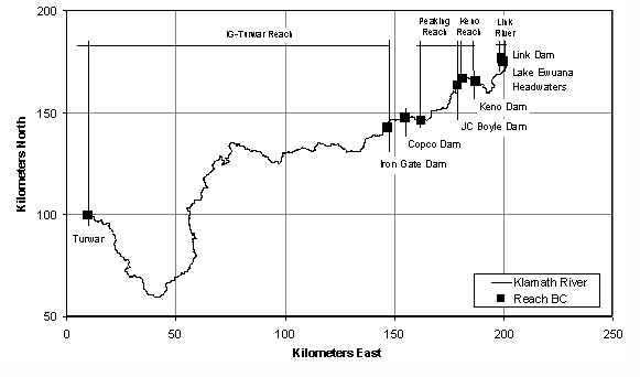
A. MODEL DESCRIPTION
- PacifiCorp has developed flow and water
quality models for the Klamath River, specifically
from Link Dam (RM 255) to Turwar, California (RM
6). The models can analyze water quality from Link
Dam to Iron Gate Dam and below, and show how the
PacifiCorp facilities contribute to or control
water quality conditions in and downstream of the
dams. The models can address questions related to
PacifiCorp operations including (1) whether and
how operations might contribute to water quality
conditions, and (2) whether and how operations
might feasibly contribute to water quality
improvements.
- PacifiCorp formally offered the use of the
models to California, Oregon, and EPA in a letter
dated January 14, 2004.
- Flow and water quality conditions in the
Klamath River basin vary dramatically in the
approximately 250 miles from Link Dam, near
Klamath Falls, Oregon, to Turwar, California.
There is a wide range of natural and anthropogenic
influences in the Klamath River system throughout
this region:
- Inflows at Link Dam originate in
hypereutrophic Upper Klamath Lake.
- There are four major reservoirs on the
mainstem Klamath River below Upper Klamath Lake:
Keno, J.C. Boyle, Copco, and Iron Gate Reservoirs.
- Diversions and return flows for agriculture,
as well as municipal and industrial use, occur in
the reach between Link Dam and Keno Dam.
- The river receives considerable inflow from
tributaries as it flows toward the Pacific Ocean.
- Discrete river models and reservoir models are
applied to represent highly dynamic flow regimes
at short space and time steps. The river reaches
are represented with flow and water quality
models. The flow model output – velocity, depth, a
representative surface, and bed areas – are passed
to the water quality model. The water quality
model uses this information to simulate the fate
and transport of a wide range of physical,
chemical, and biological constituents. The suite
of river models is applied on a sub-daily time
step (maximum time step is one-hour) to capture
the short-term response of various parameters,
such as temperature and dissolved oxygen.
- Similarly, the hydrodynamic and water quality
model for system reservoirs represents a wide
range of water quality processes, including
physical, chemical, and biological. The reservoir
model interfaces with the river model.
- The models are applied in series, starting
with the uppermost reach – Link River – and
passing the output from one reach to the next.
|
Reach
|
Existing Representation |
Model(s)
|
| Link
River |
River |
RMA-2/RMA-11 |
| Lake
Ewauna-Keno Dam |
Reservoir |
CE-QUAL-W2 |
| Keno
Dam to J.C. Boyle Reservoir |
River |
RMA-2/RMA-11 |
| J.C.
Boyle Reservoir |
Reservoir |
CE-QUAL-W2 |
| J.C.
Boyle Bypass Reach1 |
River |
RMA-2/RMA-11 |
| J.C.
Boyle Peaking Reach1 |
River |
RMA-2/RMA-11 |
|
Copco Reservoir2 |
Reservoir |
CE-QUAL-W2 |
| Iron
Gate Reservoir |
Reservoir |
CE-QUAL-W2 |
| Iron
Gate Dam to Turwar |
River |
RMA-2/RMA-11 |
|
1 The J.C. Boyle bypass and peaking
reaches are modeled as a single reach. 2
Copco No. 2 is small, and not represented
in the framework. |
B. MODEL APPLICATION
- The model has been calibrated, and simulates
system conditions from Link Dam to Turwar (a
distance of approximately 250 miles). The models
look at four system-wide scenarios: existing
conditions (EC), steady flow (SF), and two
without-Project scenarios (WOP and WOP II). These
scenarios were intended to bracket the range of
potential physical and operational conditions
within the PacifiCorp area. For each scenario, the
models were applied for a full calendar year for
the years 2000 and 2001.
- The existing conditions scenario represents
the baseline status and is used for comparing
conditions without peaking hydropower operations
(steady flow scenario) and a river system without
hydropower facilities (without-Project scenarios).
The without-Project I scenario simply assumes
conditions in the absence of hydropower
facilities. Because Project reservoir storage is
assumed to be absent, this scenario results in
significant flow fluctuations (particularly in the
Keno reach) from USBR irrigation project
operations. The without-Project II scenario is an
effort to smooth river flows to produce a
hydrograph that does not exhibit the fluctuations
caused by USBR project operations.
- These analyses are intended to examine
large-scale system response over periods when
critical water quality conditions tend to occur
(spring-fall) in the Klamath River basin. The
models provide output focusing on critical
reaches, specific operations, and limited time
periods. The basic output extracted from each
scenario is hourly time series data at multiple
locations for temperature and dissolved oxygen,
and all other parameters are available at the
hourly output frequency. Processed output includes
data for daily mean, daily maximum, daily minimum,
monthly mean, and 7-day maximum average
temperature, as well as similar statistics for
dissolved oxygen.
C. PRELIMINARY OBSERVATIONS
- Utility Of Maintaining Dams In Place
- The PacifiCorp dams in the Middle Klamath are
serving important functions. Some of those
functions are attributable simply to the fact that
they create a series of lakes. Turbidity, for
example, diminishes as water moves through the
system; turbidity can be a surrogate for
particulate matter, including dead algae and other
nutrients. Particulate organic matter that
originates, or is a result of nutrients released
from Upper Klamath Lake, agricultural return
flows, and municipal and industrial inputs in the
Klamath Falls area is to a large extent trapped by
system reservoirs (settles out), reducing the
overall nutrient load to the reaches below Iron
Gate Dam.
- All of the reservoirs are "productive," and
organic loads are elevated in all of them;
however, Upper Klamath Lake is in general several
times as "productive" as Iron Gate and Copco
reservoirs. Further, Upper Klamath Lake is a much
larger body of water with a large surface area,
and can produce appreciable organic inputs to the
Klamath River. Comparatively, Iron Gate and Copco
reservoirs have much smaller surface areas and,
although productive, do not yield the same loading
potential as Upper Klamath Lake. These reservoirs
thus have a considerably smaller impact on
releases to the Klamath River than Upper Klamath
Lake.
- Consequences of Dam Removal
- Under current conditions even if all the dams
were removed below Link Dam, the resulting river
reaches could not assimilate or retain anywhere
near what the dams now assimilate or retain.
Basically, without the dams, there is potential
for water with substantially impaired water
quality to flow downstream to the middle Klamath
River reaches. Without the current impoundments in
place, water would reach the area of Iron Gate Dam
in two to three days versus six to eight weeks.
The dams are beneficial for water quality, because
the water quality from Upper Klamath Lake and the
agricultural return inputs (e.g., Straits Drain,
Lost River Diversion Channel) is severely
impaired, and the reservoirs trap appreciable
amounts of matter, thereby reducing the load to
downstream reaches.
- If Iron Gate Dam were removed, the river below
Copco I and II developments would be slightly
warmer than the river below Iron Gate Dam because
Copco is smaller and has a smaller cold water
pool. There would be unknown silt impacts
downstream of Iron Gate Dam upon removal. There
would still be "thermal lag," even without Iron
Gate Dam, since the Copco Dam would continue to
have a thermal lag effect. Finally, cold water in
Iron Gate Dam is a source of water for the fish
hatchery, so removal would result in no cold water
supply for the hatchery.
- Removing Iron Gate Dam would restore
approximately eight river miles, with resultant
increase in mainstream reaches, and some spawning
habitat. It is estimated that of the
eight miles of restored
stream, only 17 percent would be spawning habitat.
There are only three tributaries to which access
would be regained – Camp, Jenny, and Fall Creeks.
Flows and access to Camp and Jenny Creeks are
substantially impaired. On Fall Creek, the City of
Yreka can divert up to 15 cfs of the normally
available 40 - 50 cfs tributary flow.
III. Fish Passage And ANADROMOUS FISH
REINTRODUCTION
A. MODEL DESCRIPTION
- PacifiCorp, in consultation with stakeholders,
is using two models (KlamRAS, EDT) to examine fish
passage and anadromous salmon reintroduction
strategies in stream reaches upstream of Iron Gate
Dam. The base data have been entered for the
models for Project dams and reservoirs, as well as
stream reaches up to Spencer Creek (below Keno
Dam). The Habitat Modeling Group (HMG) is
currently in the process of reviewing data inputs
for these reaches and ranking habitat data for
approximately 250 miles of stream and lake habitat
upstream of Keno Dam. This data will be entered
into the Ecosystem Diagnosis and Treatment model
(EDT) and used to examine fish production
potential of the Upper Klamath River basin.
- EDT is a state-of-the-art habitat model, which
incorporates habitat features and biological
productivity into the analysis of fish passage
options. It provides a comprehensive habitat based
tool to address the success of restoring
anadromous fish runs to the upper Klamath River
basin above Iron Gate Dam. This model is being
used by state, city, tribal and federal agencies
to address salmon restoration throughout the
Pacific Northwest. The habitat inputs used in EDT
modeling are being developed from various sources,
including:
- Results of water quality, geomorphology, and
project operations studies conducted as part of
relicensing;
- Studies conducted by other parties in the
upper and lower Klamath River basin, including
information on juvenile emigration timing,
migration speed and survival in the Lower Klamath
River, effects of disease on native fish
populations, run-size estimates, estuary
conditions and mainstem habitat quality and
quantity;
- Historical fisheries literature developed both
within and outside the Klamath River basin; and
- Expert opinion of the HMG members familiar
with Klamath River habitat and fish reintroduction
efforts in other basins.
- The habitat quantity and quality outputs from
EDT are being used as inputs into KlamRAS. KlamRAS
is being used to focus on dam and reservoir
passage efficiencies so that passage options
(operations, facilities) can be assessed. The
KlamRAS model incorporates both habitat data (from
EDT) and fish passage survival through Project
structures to estimate fish production in specific
reaches or areas of the basin. The model can
explore how different assumptions affect model
results; this model is being used primarily as a
"gaming" tool to assess the effects various fish
passage options have on fish production.
B. MODEL APPLICATION
- EDT Model outputs for the Klamath include
estimates of chinook, coho, and steelhead
productivity, capacity, and diversity. These three
parameters are defined by NOAA Fisheries as needed
to evaluate the viability of salmon populations.
The model allows the user to identify key reaches
for restoration or protection.
- The KlamRAS model is being used to examine
different project configurations to estimate
impacts on anadromous fish production and
survival. The alternative scenarios include dam
removal, volitional passage through fish ladders
and screens, and trap-and-haul systems located at
various locations in the Project area. It is
envisioned that the model will be used to conduct
sensitivity analysis on all input parameters to
identify the critical uncertainties that drive
model outputs, and thus the feasibility of
reintroducing anadromous fishes to the upper
basin.
C. PRELIMINARY OBSERVATIONS
- Preliminary model runs show that even when
passage survival through reservoirs and dams is
assumed to be high, resulting fall chinook salmon
production is still quite low and probably not
sustainable. With the removal of Iron Gate Dam,
fall chinook adult returns increase to
approximately 1,000 spawners. Factors responsible
for low estimates of fish returns include: high
chinook harvest rates (15% ocean, 30% freshwater),
disease (Ceratomyxosis), and poor water
quality. The major water quality problem
identified through modeling, even with Iron Gate
Dam removed, is high water temperatures (>21 C)
that occur during the peak juvenile migration
period for this species. Water temperatures at
this level put considerable stress on salmon
populations; which in turn make them highly
susceptible to disease.
- The removal of Iron Gate Dam increases total
mainstem Klamath River habitat from 194 miles to
approximately 202 miles (an increase of
approximately eight miles). The removal of Iron
Gate Dam only allows anadromous fish access to
three tributaries of any size: Camp Creek, Jenny
Creek and Fall Creek (less than a combined 5 miles
of usable habitat), and a significant amount of
both Jenny Creek and Fall Creek streamflow is
diverted for water supply purposes and irrigation
needs. Unless flows are restored, model results
show little anadromous production is possible from
these streams.
- Based on initial analyses, the HMG has
concluded that stream habitat upstream of the
Project area would be critical to the success of
any reintroduction effort. The group is evaluating
habitat potential upstream of Keno Dam.
- The preliminary conclusions of modeling are
not surprising, and confirm the findings of three
previous reviews of the reintroduction issue.
Reports produced by Fortune et al., (1966),
Klamath River Basin Fisheries Task Force (1992),
and ODFW (1997) pointed out the problems that need
to be overcome to re-establish anadromous fish to
the Upper Klamath River. As summarized by ODFW
(1997): "Because of existing habitat problems,
loss of native stocks, risk of disease
introduction and potential competition with
remaining native redband trout, it does not appear
feasible, or prudent, to attempt re-establishment
of anadromous salmon or steelhead to the Upper
Klamath Basin in Oregon, now or in the future".
- Notwithstanding the findings of these previous
reviews, PacifiCorp has committed significant
resources to conduct what is probably the most
intensive review of the anadromous reintroduction
issue undertaken to date.
IV. FOCUS ON TRIBUTARY OPPORTUNITIES
- PacifiCorp endorses the principle that a
global effort is needed to address all of the
myriad issues related to the Klamath River system.
However, PacifiCorp is also committed to exploring
efforts to accomplish the most immediate and
effective possible improvements to the basin to
improve the Klamath River fishery.
- Opportunities on the Scott and Shasta Rivers
could be developed in the near term. The positive
effects of tributary improvements promise to be
vastly superior to any which could be postulated
as a result of removal of Iron Gate Dam. Because
of the importance of finding near-term effective
and significant improvements to the system and the
fishery, every effort should be made to explore
those alternatives on a priority basis, with
priority given to tributary efforts consistent
with both the National Academy of Science study
and the California Department of Fish and Game
Draft Recovery Strategy.
V. CONCLUSION
Dams are not usually thought of as "good for
water quality." On the Klamath River, however, dams
have important positive water quality effects.
Removal of Iron Gate Dam – under current conditions
– is not a good idea because of severely impaired
water in upstream reaches, namely Upper Klamath Lake
and the Reclamation project, which would wash down
into the middle Klamath, with resulting degraded
conditions (low DO, increased primary productivity,
elevated pH, unionized ammonia issues, increased
turbidity). If Upper Klamath Lake were "restored" to
some as yet to be determined level, the removal of
Iron Gate Dam or other facilities could be used to
increase juvenile and adult survival through the
Project area. Even then, however, there are other
alternatives besides dam removal that could be
implemented to achieve this same result.
As can be seen from a review of previous
investigations of the feasibility of restoring
anadromous fishes to the Upper Klamath River basin,
the hurdles that need to be overcome to make
reintroduction a reality are tremendous. Problems
include a lack of suitable stocks for
reintroduction, possible disease impacts on native
redband trout population, poor water quality, fish
survival and passage through the lake environments,
dam complex, and the 194 miles of mainstem Lower
Klamath River.
From a water quality perspective, restoring Upper
Klamath Lake and reoperating and reconfiguring the
Reclamation project to minimize and mitigate
potential downstream impacts is also an enormous
challenge. It is crucial to look at current
conditions, particularly the severely impaired
conditions in the Upper Klamath Lake and the
Reclamation project, in determining the most
effective course of action for recovering ecosystem
function and fish stocks in the Klamath River basin.
Because removal of Iron Gate Dam would have an
overall negative effect on water quality below the
dam at this time, it makes the most sense to focus
fish recovery action now, and for the foreseeable
future, on restoring Shasta and Scott River habitat,
and to endeavor to reverse the hypereutrophic state
of Upper Klamath Lake and improve the water quality
of Reclamation return flows over the long haul.
Focusing our actions and resources in the Scott and
Shasta River allows us to provide immediate benefits
to the chinook, coho and steelhead populations of
the basin. In contrast, benefits to basin fisheries
resources from a reintroduction effort in the Upper
Klamath basin will not be realized for decades into
the future, with no guarantee of success.
|