Our Klamath Basin Water Crisis
Upholding rural Americans' rights to grow food,
own property, and caretake our wildlife and natural resources.
Our Klamath Basin
Water Crisis
Upholding rural Americans' rights to grow food,
own property, and caretake our wildlife and natural resources.
|
https://www.heraldandnews.com/news/local_news/counting-every-drop-klamath-basin-water-year-tracker/article_d72a3e50-05e4-5871-9f58-54fd387a6580.html
Counting Every Drop Herald and News by Alex Schwartz 11/13/21
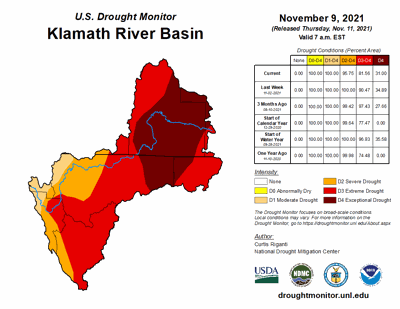
The Herald and News is launching monthly hydrologic updates for the Klamath Basin. Around the middle of each month, we'll compile on-the-ground data to inform stakeholders about how the current water year is shaping up. If you have suggestions or requests for water-related data you'd like to see, please email aschwartz@heraldandnews.com. Drought Monitor The November 9 U.S. Drought Monitor map continues to place the entire Klamath Basin in some form of drought. The outlook has improved slightly in the Lower Basin since the end of September, but extreme and exceptional drought haven’t budged at its headwaters. The overall area of the Klamath Basin experiencing exceptional drought has dropped by 3.89 percent since the previous week’s drought assessment. The area under extreme drought has fallen by 8.91 percent. Precipitation
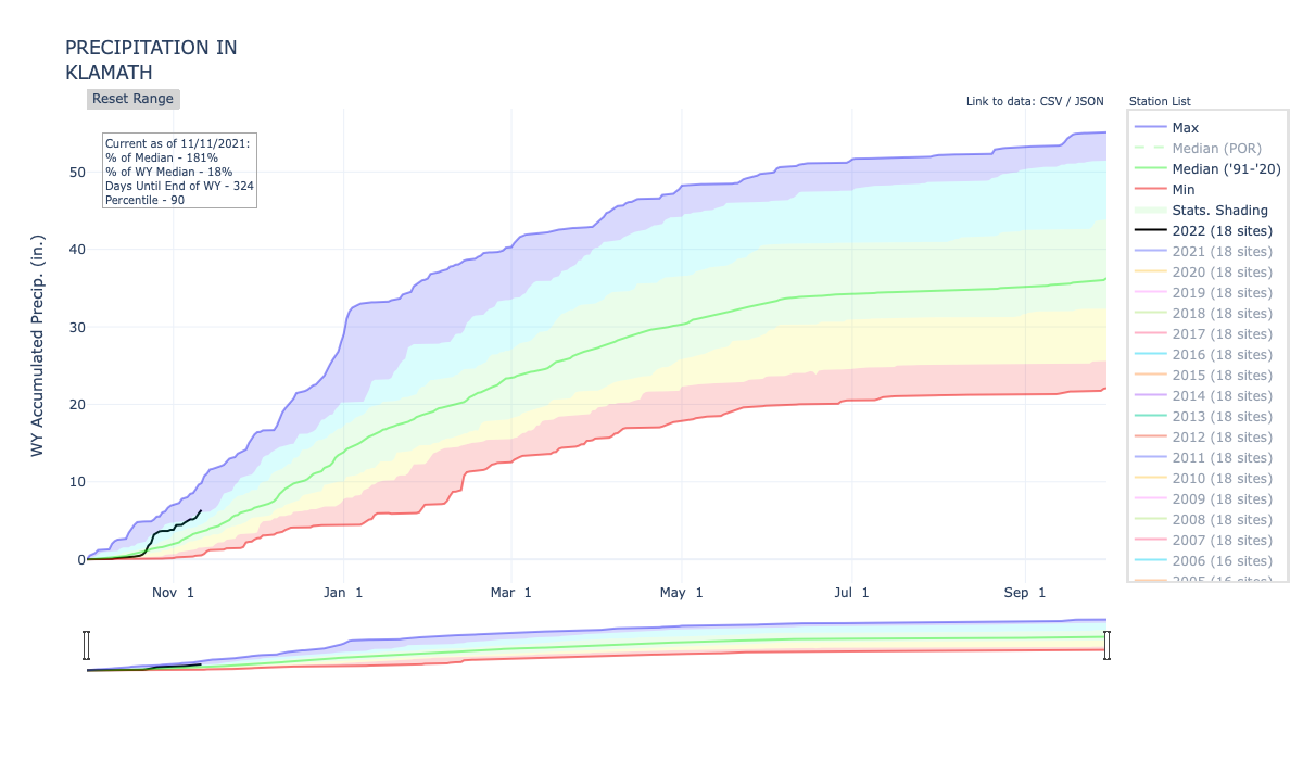
The Klamath Basin has received 5.9 inches of precipitation since October 1. That’s 173% of the median amount of precipitation accumulated by this time in the water year over the period of record. According to the National Weather Service, this October was the fifth wettest for the Klamath Falls Ag Weather Station since records began in 1970. A series of intense atmospheric rivers brought beneficial precipitation to the area toward the end of the month, dumping as much as two inches on Klamath Falls in four days. However, given how early it is in the water year, well-above-average precipitation hasn’t made much of a dent in the intense, multi-year drought the basin is experiencing. Snowpack
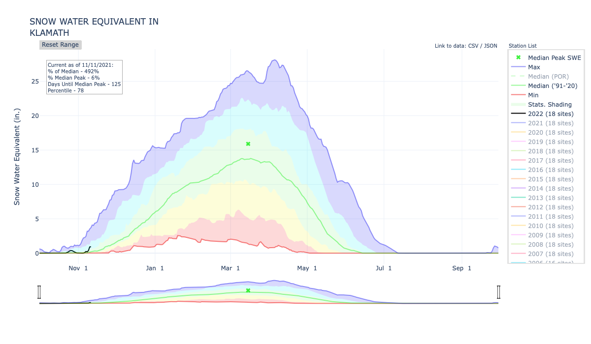
Natural Resources Conservation Service SNOTEL sites in the Klamath Basin report above average snow-water equivalent, about 0.9 inches or 486% of the median typically accumulated by this time of year. However, as with precipitation, this is a small amount that will not significantly counteract drought conditions and could even melt out with warmer temperatures before winter officially begins. Soil Moisture
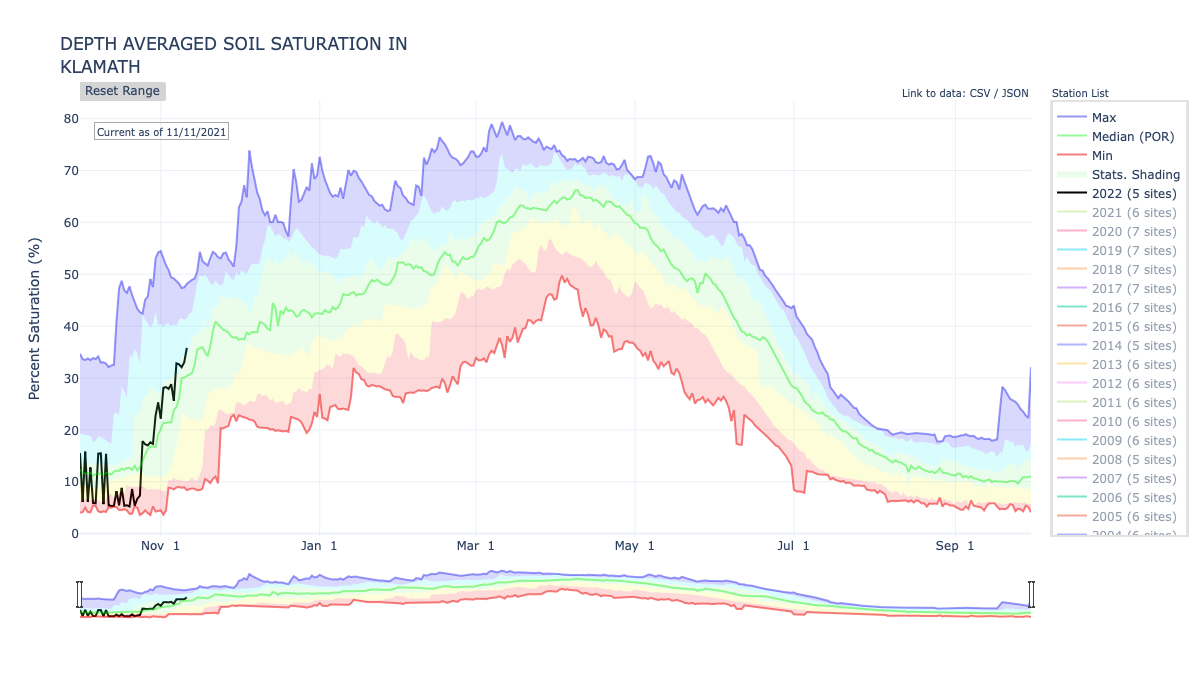
Soils in the Klamath Basin are 35.8% saturated, which is slightly above normal for this time of year based on the period of record that began in 2004. Sufficient fall rains are crucial to ensure soils remain wet enough to allow snowmelt to enter streams and aquifers come spring and summer. Streamflows and Lake Levels
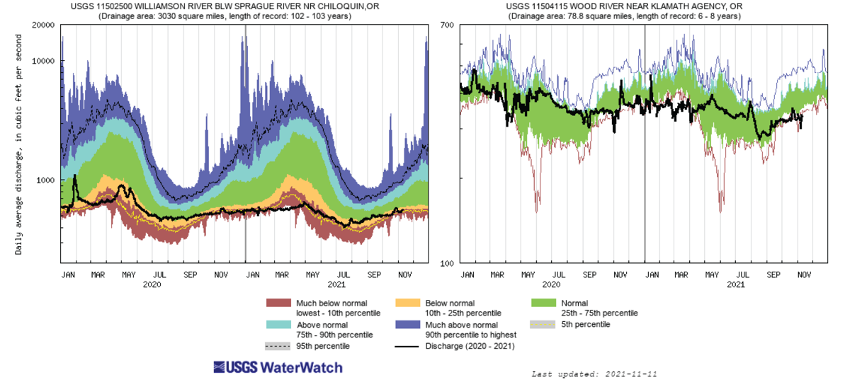
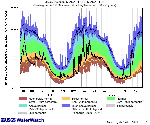
Despite the rain, tributaries to Upper Klamath Lake are still flowing at rates well below normal. The streamflow gauge on the Williamson River below Chiloquin measured 556 cubic feet per second on November 11, below the 25th percentile for this time of year. The Wood River near Klamath Agency is discharging at 338 cfs, also within the lowest quartile.
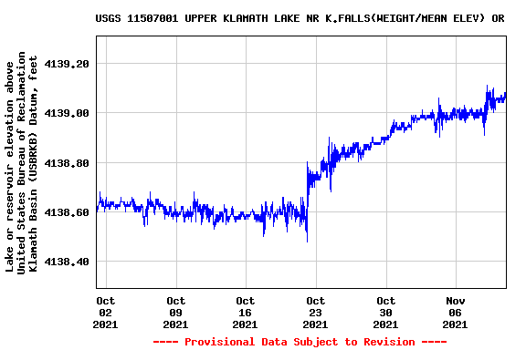
Upper Klamath Lake’s elevation has hovered above 4,139 feet since the beginning of November and is steadily increasing. This summer, lake never went below 4,138.5 feet in elevation, the minimum level required by the Endangered Species Act. Per the Bureau of Reclamation, Upper Klamath Lake is currently 37% full, Gerber Reservoir is 2% full and Clear Lake is 13% full.
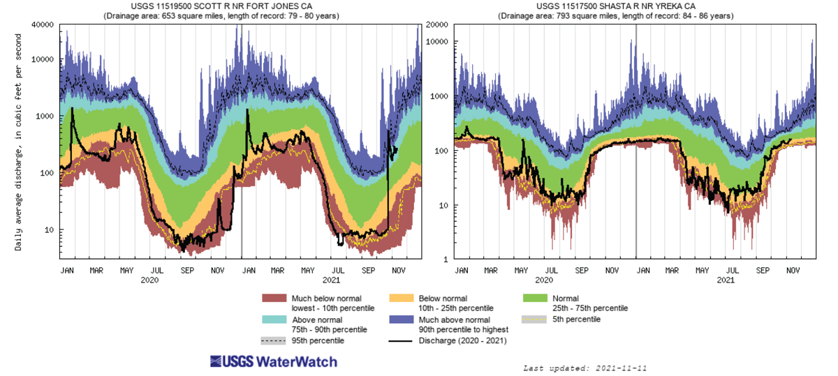
The Scott River has been flowing well above normal since the end of October. Its most recent read at the Fort Jones gauge was 267 cfs. The Shasta River at Yreka was flowing below normal at 155 cfs on November 11, the 25th percentile for that time of year. Both flows currently meet the emergency instream requirements for migrating salmon, which were set by the California Water Resources Control Board this summer.
==================================================== In accordance with Title 17 U.S.C. section 107, any copyrighted material herein is distributed without profit or payment to those who have expressed a prior interest in receiving this information for non-profit research and educational purposes only. For more information go to: http://www.law.cornell.edu/uscode/17/107.shtml |
Page Updated: Monday November 22, 2021 01:35 PM Pacific
Copyright © klamathbasincrisis.org, 2001 - 2021, All Rights Reserved