Date: September 17,
2009
To: Mr.
Fimrite, Staff Writer
San Francisco Chronicle
pfimrite@sfchronicle.com
From: Carolyn
Pimentel, Interim Scott River Watershed Council Coordinator
P. O. Box 268
Etna, CA 96027
(530) 467-3975
sisqrcd@sisqtel.net
RE:
Sunday, September 13, 2009
“DROUGHT Parched river endanger fabled Klamath
salmon run”
Attachments:
photo and
graph
Message: The
Scott River Watershed Council would like corrections made to the
inaccuracies stated about the Scott River in the above
referenced article. We would appreciate a follow-up article
given the same front page attention as the original article with
the attached photo and graph, and the following corrections and
pertinent additional information:
- 2009 is a "Critically Dry" water year (40-50% of normal
precipitation, similar to 2001), following 2 previous "Dry"
water years in '07 and '08. The very low snowpack helped
reduce streamflows earlier than in a normal or wet water year.
Nothing in the article describes the extremely low
precipitation experienced by this region.
An ad hoc committee to
the Scott River Watershed Council is currently working on a
Critically Dry and Dry Year Plan. Classifications of
“Critically Dry” and “Dry” water years are based on
hydrological data.
Coho salmon in the
Klamath Basin are listed as “threatened” under ESA and CESA,
not “endangered” (as stated in article). The Scott River
supported 1,622 coho salmon spawners in 2007, possibly the
largest natural coho run in any river that year. Coho salmon
are closer to going "extinct" in Santa Cruz County through
Sonoma County (where they are listed as "endangered") than
they are in Siskiyou County.
Coho salmon spawners do not enter the Scott River until
November, with their peak usually around Thanksgiving. Much
can change in increased runoff conditions by then, based on
many years of experience. The present condition of these
tributaries does not reflect the condition that the coho will
experience in 2 months.
Fall Chinook salmon
spawners are in the lower Klamath River in early September,
and 2009 is expected to be a good run. They usually do not
enter the Scott before early October and peak about early
November. The run in the Scott is about 2 weeks later than the
Shasta's.
Water releases from Irongate Dam on the Klamath and
Lewiston Dam on the Trinity River are timed to invite the fish
up into the lower Klamath River to celebrate Labor Day sport
fishing and various Tribal ceremonies. However, in this dry
year, such flow schedules invite stranding or harmful flow and
temperatures before natural seasonal changes create favorable
migration conditions for spawners.
The USGS Gage for the
Scott River is at River Mile 21 which is @ 7cfs today. We know
from experience that we need about 23-25 cfs at the Gage to
get the spawners past some rocky flow barriers into the lower
Scott Valley, where good spawning gravels are located.
Spawning also occurs in the lower river within the canyon
reaches.
The Scott River's lower 23.5 miles (from the Scott's mouth
at the Klamath up to Shackleford Creek's confluence) are
connected by streamflow. Chinook spawning can occur in this
lower river reach below Scott Valley.
No adult coho, Chinook, or steelhead are "stranded" in
"shallow, disconnected pools of water" since they have not
migrated upstream yet and are not in these dry reaches. The
flows have bottomed out and will gradually increase as days
get shorter, trees and vegetation go dormant, and fall rains
come.
Various reaches in the
Scott River above Shackleford Creek are either dry between
standing pools (especially the sandy reaches, where the
newspaper photo was taken) or low flowing. We've had similar
flow situations in the valley during at least 1989-1991, 1992,
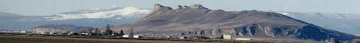
1994, 2001, 2002, and 2007 -- all drought years.
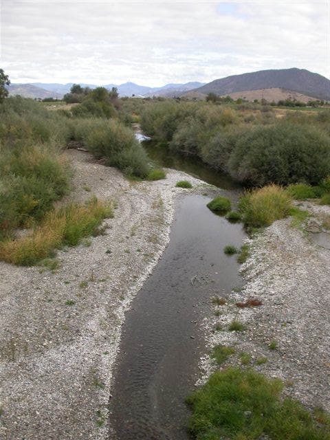
The pool of water pictured on the front page of your
Sunday edition article indicates that the water table is not
far below the streambed surface, indicating that not much
surface flow will be needed to connect the isolated pools in
this reach of the middle Scott River. Photo taken at river
mile 35.
Attached photo taken today at river mile 44. This
photo indicates a reach that is connected upstream of that
site in the Sunday article. Water use by all plants is
declining now with cool temps and shorter days, so streamflow
will be coming up.
Chinook and coho
spawners were able to come up to spawn in Scott Valley after
flow naturally increased due to rain each year except for
1994, when the gage was only 13 cfs on Dec. 1st (our worst
case scenario with no rain for months).
The Chinook salmon run has fluctuated on the Scott River
since records began in 1978, as can be seen on the attached
graph. Recent runs have averaged about 4,600 adult salmon,
with as many as 12,000 fish as recently as 2003.
Fishing (commercial)
was curtailed on the ocean off the North Coast for a few years
due to low spawner return numbers in the Klamath, but was
allowed again in 2008 and 2009 due to higher returns, while
ocean fishing off San Francisco was closed these past two
years due to the Sacramento's low return numbers. The article
did not get this difference correct.
Since 2007, the Scott River Water Trust has been seeking
to increase fall flow conditions in the mainstem Scott River.
Leasing water from ranchers' ditches in October helped
reconnect the dry reaches in 2007 and we'll try again this
year. In 2008, there were no long dry reaches but several
water leases again helped get the gage past 25 cfs earlier
than if nothing had been tried. The Scott River Water Trust is
the first active water trust in California. See the Water
Trust's website for more information:
www.scottwatertrust.org
The Sunday article stated that our two rivers (Scott and
Shasta) are a main source of cold water for the Klamath. The
Scott contributes about 5% on average to the Klamath River's
average flow this time of year, and the Shasta less. This
amount of water contribution cannot significantly "cool" the
Klamath's water in comparison with the Klamath River. Also,
if the flow contribution from the Scott could be increased
(predominantly predicated on Mother Nature), it would not be
contributing cool water this time of year. See the Scott River
Temperature TMDL report by the North Coast Regional Water
Quality Control Board.
Total Irrigation
acreage and water demand have not increased in the Scott
Valley over the past 50 years, based on Calif. Dept. of Water
Resources (DWR) data. Water demand varies year by year,
however, depending upon soil moisture conditions, crop prices,
and other factors.
By October 1st
irrigation is done in Scott Valley, especially this year with
a very long and cool spring the first cutting of hay was
delayed, and with hay prices low, irrigation costs high,
farmers are just finishing their 3rd cutting of
hay. In the Scott Valley on a good haying year some may get 4
cuttings here. By late September, everyone has their last
cutting up as haying conditions into October are not
predictable or favorable for hay production.
After October 1st or 15th, depending
on which adjudicated water right the surface diversion falls
under; it's stockwater that is being diverted. The Siskiyou
Resource Conservation District (RCD) (for the Scott Valley
area) has a successful alternative stock water program to
assist ranchers in changing over from surface diversions for
stock water to efficient water-saving stock watering systems
allowing for more water to stay in the stream.
|