Gage height, feet
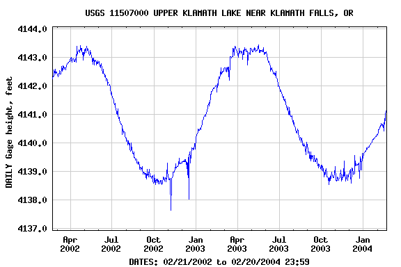
| Most recent value: 4,141.15 02-20-2004 04:00 | |
|
|
| Download a presentation-quality graph | Parameter Code 00065; DD 01 |
PROVISIONAL DATA SUBJECT TO REVISION |
||
Station operated in cooperation with
PacifiCorp.STATION.-- 11507000 UPPER KLAMATH LAKE NEAR KLAMATH FALLS, OR LOCATION.--Lat 42° 15'00", long 121° 48'55", in NW 1/4 SW 1/4 sec.19, T.38 S., R.9 E., Klamath County, Hydrologic Unit 18010203, at southeast end of lake, 1.4 mi upstream from outlet and 2.5 mi northwest of Main Street Bridge at Klamath Falls. DRAINAGE AREA.--3,810 mi2, approximately, including 26.2 mi2 in closed basin of Crater Lake. PERIOD OF RECORD.--May 1904 to September 1922 (gage heights only), October 1922 to current year. Monthend contents only October 1923 to September 1927, published in WSP 1315-B. GAGE.--Water-stage recorder. Datum of gage is 4,098.22 ft above NGVD of 1929, or 4,100.00 ft above Bureau of Reclamation datum. Gage readings have been reduced to elevations above Bureau of Reclamation datum. See WSP 1735 for history of changes prior to Nov. 10, 1923. Since Oct. 1, 1974, supplementary water-stage recorders at sites 7 mi north and 21 mi northwest at same datum (water-surface transfer by Pacific Power and Light Co.). REMARKS.--Reservoir is formed by concrete dam at outlet of natural lake, completed in 1921, replacing a temporary dam built in 1919; controlled storage began Apr. 15, 1919. Capacity, 523,700 acre-ft between elevations 4,136.0 ft and 4,143.3 ft. Dead storage below elevation 4,136.0 ft is 211,300 acre-ft. Stored water may be diverted through "A" Canal for irrigation on land under Klamath project of Bureau of Reclamation, or released to Link River through dam or powerplants at Klamath Falls. Contents given herein represent those above elevation 4,136.0 ft. Prior to Oct. 1,1973, contents given represented those above elevation 4,135.0 ft. Prior to Sept. 30, 1974, contents at end of month obtained by averaging elevations for last 3 days of month and first 3 days of following month to compensate for wind effect. Since Oct. 1, 1974, daily elevations are weighted mean of elevations at base and supplementary gages; contents at end of month are obtained from weighted midnight elevations of base and supplementary gages. EXTREMES FOR PERIOD OF RECORD.--Maximum elevation, 4,144.98 ft about Apr. 20, 1904, from high-water marks; minimum recorded, 4,135.55 ft Oct. 30, 1944.
|
||
Gage height, feet |
|||||||
|
|||||||
| Questions about data | gs-w-or_NWISWeb_Data_Inquiries@usgs.gov | Top |
| Feedback on this website | gs-w-or_NWISWeb_Maintainer@usgs.gov | Explanation of terms |
0.87 0.88 nadww01