Our Klamath Basin Water Crisis
Upholding rural Americans' rights to grow food,
own property, and caretake our wildlife and natural resources.
Our Klamath Basin
Water Crisis
Upholding rural Americans' rights to grow food,
own property, and caretake our wildlife and natural resources.
|
Part 1 - Siskiyou County How Water and Land Use Regulations and Litigation Are Destroying Us
By Marcia H. Armstrong © 2012
Background on
GENERAL:
Sixty-three % (63%) of the land base in
The entire land base of
In the year 2000, the average unemployment rate for the year was
7.5%. By 2008, it had risen to 10.2%, rising again to 15.8% in
2009. In March of 2012, the unemployment rate was 18.7%, ranking
Siskiyou 50th out of 56 counties in the state. There are many
forest-dependent communities in our county where local
unemployment is estimated from 30-40%. The average wage per job
in 2008 was $32,707. That was only 63% of the state average. The
median household income was $36,823 — or 60% of the state
median. Non-household median income is currently $27,718 — a
ranking of 47th in the state. The AP
Economic Stress Index ranks
Siskiyou
Social statistics indicate that Siskiyou County has the second
highest child
abuse/neglect rate in
the state - (3 times the state average.) Compared
to
According to Indicators of Alcohol and Other Drug Risk and Consequences for California Counties Siskiyou County 2007, the number of local fatalities in alcohol-involved motor vehicle accidents was three times that of the statewide average; the death rate due to alcohol and drug use was 32.5 deaths per 100,000 persons (compared to a state average of 20.9/1000.) Methamphetamine accounted for 44% of admissions for alcohol and drug treatment. Admissions for alcohol use accounted for 31 percent of admissions in 2004. The death rate for cirrhosis if the liver was three times the Healthy People 2010 goal. Drug-induced deaths were 19 times higher than the Healthy People 2010 goal per 1,000. About 85% of child abuse cases involve methamphetamine.
The economy of
Agriculture is a major economic sector of the county. Our 2010 Siskiyou
County Annual Crop and Livestock Report indicates
that the agricultural valuation in the county was $195,711,956
(gross and excluding timber.) According to the USDA
Ag Census, in 1992
During the past 20 years, there has also been a restructuring of
size and sales in agricultural operations. Since 1992 to 2007,
there has been an increase in the number of small farms: farms
under 10 acres doubled to 80. Farms under 50 acres increased 59%
to 229. Farms 50-179 acres increased 27% to 228. Farms from
180-449 acres remained about the same at 79. However, there was
a 19% reduction in farms 1000 acres or more to 100 farms in
2007. One aspect of this is land conversion from private to
Federal lands. Since 1999, 8,625.71 acres valued at $3,922,179
have been converted to Federal land. Another 11,236 acres of
ranch land in the
At the same time, farms having less than $2,500 in sales increased 105% to 359. Farms selling $2,500-9,999 stayed about the same at 151. Farms selling $10-$24,999 decreased 10% to 95. Farms selling $25,000-$49,999 decreased about 18% to 60. Farms selling $50,000 to $99,999 decreased 45% to 44 and farms with sales in excess of $100,000 increased by 28% to 137.
There is no doubt that the restrictions on timber harvest from
public lands under the Northwest Forest Plan have played a
significant role in this decline. In 1978, 239 MMBF of timber
was harvested from the Klamath National Forest (KNF), 274 MMBF
from the Shasta Trinity National Forest (STNF) and 73 MMBF from
the
AGRICULTURAL AREAS: The Klamath basin drains approximately 16,000 square miles
with 35% of the watershed in
Siskiyou County's agricultural centers include the Scott Valley,
the Shasta Valley, the Butte Valley and the Tulelake areas.
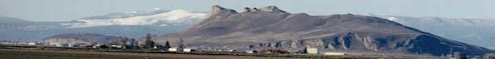
(left to right) In 2010, the total market value of non-timber
agricultural crops and livestock inventories in
Siskiyou County was $195,711,956. (Siskiyou
SCOTT VALLEY:
Scott Valley is a 814 sq. mile basin (or 520,968 acres.) Base elevation at Fort Jones is 2,747 feet. The mean temperature ranges from 33°F in winter to 70°F in summer. Extreme temperatures range from high of 110°F and low of -23°F. The growth season is 143 days. Sixty one percent of the land base is privately owned (or 316,471 acres.) Of these, 32,443 acres are irrigated. The number of irrigated acres in Scott valley has not changed substantially since 1950. (It was 34,100 acres in 1988.) Methods of irrigation, (flood, wheel lines, pivot wheels,) have changed over the years. In 1968, when water was more commonly diverted for flood irrigation, 86% of irrigation was through diversion of surface water, 2% groundwater and 12% mixed. In 2000, 48% was surface water, 45% groundwater and 7% mixed. [Siskiyou RCD and Scott River Watershed Council restoration projects; Siskiyou RCD; Scott River Watershed Council; Scott River Water Trust] Crops are mainly pasture, alfalfa and grain. Cattle and other livestock are raised. There is a large nursery operation for reforestation. The average precipitation is 21.78, with annual snowfall of
30.4 inches. However, the western portion of the valley and the
south side mountains average substantially greater rainfall than
the eastside. Summer and fall flows in the Scott vary from year
to year, but are largely controlled by the precipitation and
snowpack of the prior 12 months. (Drake, Tate and Carlson) From
1951-1998, there has been a decrease in the water content of the
snowpack in the area, particularly in the western mountains.
There has been a correlating decline in According to a presentation by Dr. Thomas Harter of U.C.
Davis, the average annual discharge in the In the early twentieth century, large Yuba type gold mining
dredges ran in the Because of the discovery of gold on the Scott River, Scott Valley was settled by non-Indian miners and farmers in the 1850s. (Many of the small family ranches and farms are 150 years old and operated by 5th or 6th generation descendants.) Appropriative and riparian water rights [i] here are vested [ii] and among the oldest in post-Mexican California. Almost all of them pre-date the 1911 declaration by the California Legislature (Calif. Stats. April 8, 1911, pg. 821) [iii] that "all water or use of water within the state of California is the property of the people of the state of California" and the 1914 California Water Commissions Act (Calif. Water Code 2774) [iv] when all new appropriations of surface water required either a certificate of registration (for small scale domestic use,) or a permit (leading to a license.)[v][California Water Rights Fact Sheet]The Scott River adjudication : decree no. 30662 : Scott River stream system, Siskiyou County / Superior Court for Siskiyou County was entered on January 30, 1980. The water rights set forth in the decree include use to all surface waters that contribute to the flow of the Scott River stream system, including rights to tailwater, waste and return flow, supporting underflow and interconnected ground water, (a maximum of 500 feet adjacent to the river as delineated on the State Water Resources Control Board map,) and excluding Shackleford and French Creeks and their tributaries - previously adjudicated in 1950 and 1958 respectively. Ground water outside the delineated area is not adjudicated. A diverter may take his adjudicated amount either by surface or groundwater in the interconnected zone. The adjudication identifies 40 tributaries or stream groups that are independent in respect to non-surplus rights on other streams or stream groups. Rights to divert the natural flow of the main stem Scott River are separated into 5 separate sections. Non-surplus rights within each section may be exercised independently from those in another section but relative to the priority established for the section in which they lie. Post-1914 appropriative rights are held to be inferior to all other rights except surplus rights. (This included 34 permits, 41 licenses and 7 stockpond certificates.) Irrigation season is established "from about April 1 to about October 15 of each year." Diversion structures must be constructed to allow an water in excess of the specific diversion allotment to pass to the stream channel to allow passage of fish during irrigation season, but prior to about June 1. Those with gravel diversion dams must breach the dam at the end of the irrigation season to allow adult fish to ascend to spawning grounds. There is no general limitation for consideration of fisheries during the period between June 1 and October 15. However, the U.S. Forest Service has a quantified riparian right to instream flows for minimum level fishery subsistence and use by wildlife within the Klamath National Forest. The USFS also has an additional quantified right to instream flows for incremental fish flows, recreational, scenic and aesthetic purposes. These rights are of a first priority basis, correlative to other first priority rights included in the section beginning at the USGS gaging station at Fort Jones and in specified amounts on specified tributaries. Although all rights to "surplus waters" in all section are junior to the USFS rights, the USFS instream rights have no relation to non-surplus rights in other sections and non-specified independently adjudicated tributaries. The CA Dept. of Fish and Game attempted to make a claim for instream flows for fish. They were denied by the court because they owned no "reserved" riparian land for that purpose and because an appropriative right requires actual "possession" or taking control of water - not just instream. The decree states that the Superior Court of Siskiyou County retains continuing jurisdiction of parties to these proceedings, and of the subject matter hereof, including motion by the State Water Resources Control Board to review its decree and to change or modify the same as the interests of justice may require. Comments made by the California Department of Fish and Game in connection with the filing of the 1974 Adjudication "Notice of Intent" included the following: "Problem sections of the stream noted for going dry or intermittent flows during the summer months: (1) Scott River at river mile 50 for 1-3 miles below the diversion ditch; (2) East Fork Scott River below diversion dams; (3) Etna, Kidder and Patterson Creeks over several miles of lower reaches; (4) Sniktaw and Shackleford Creeks near mouths; (5) Patterson Creek (near Meamber Bridge) and Indian Creek; (6) Moffet Creek." State of CA SWRCB Order WR 98-08 In the Matter of the Declaration of Fully Appropriated Stream Systems in California includes the Scott River.
SHASTA VALLEY
Shasta Valley is a 795 sq. mile basin (or 508,734 acres.)
Base elevation at Montague is 2,640 feet. 72% of the land is
privately owned (364,729 acres.) There are from 50-55,000
irrigated acres. Precipitation averages l2.12 inches annually
with 75 to 80 percent of it occurring between October and March.
Annual snowfall averages 8.9 inches. The length of the average
growing season is about 175 days. The average seasonal runoff
is 160,000 acre feet of water. The mean temperature ranges from
34 Crops are mainly pasture, alfalfa and grain. Cattle and other livestock are raised. Mount Shasta, a compound
stratovolcano rising
to an elevation of 4,317 meters, dominates the south end of
Shasta Valley. The debris-avalanche deposits underlie the
western two-thirds of The Shasta River is 43.6 miles long. It originates within the higher elevations of the Eddy Mountains lying southwest of the town of Weed in Siskiyou County. It flows in a northerly direction, passing through the Shasta Valley. Numerous springs and a number of small tributary streams enter the Shasta River as it passes through the Shasta Valley. Major tributaries include Parks Creek, Big Springs Creek, Little Shasta River, and Yreka Creek. Dwinnell Dam and reservoir (Lake Shastina) provide water for downstream irrigation and the city of Montague. After leaving the valley, the Shasta River enters a steep-sided canyon where it flows for a distance of seven river miles before emptying into the Klamath at 176.6 river miles upstream from the Pacific Ocean. "Dwinnell Dam was constructed in 1928 to capture winter and early spring run-off. Originally, the dam measured 1,265 feet in length, was 98 feet high and had an effective storage capacity of approximately 34,000 acre feet. In 1955, the height of the dam was raised which increased the total storage capacity to 50,000 acre-feet. When full, the reservoir has an average depth of 22 feet with a-maximum depth of 65 feet and a surface area of 1,824 acres (2.85 mi2). Wales (1951) estimated that construction of Dwinnell dam eliminated access to about 22 percent of the total spawning habitat formerly available to salmon and steelhead and approximately 17 percent of the drainage area." ("A Biological Needs Assessment for Anadromous Fish in the Shasta River Siskiyou County, California") As a primary gold mining area, the water rights in the Shasta Valley are also very old. (Many of the small family ranches and farms are 150 years old and operated by 5th or 6th generation descendants.) On February 15, 1928, an adjudication of appropriative water rights on the Shasta River and tributaries was decreed, entitled "Order Determining and Establishing the Several Rights by Appropriation to the Use of the Waters of Shasta River and its Tributaries," (Book 1 of Orders of Determination, page 117.) A water master service was established. Prior historic agreements between individual landowners were incorporated into the adjudication. Riparian rights were not included in the adjudication. According to the decree, beneficial uses were established as: Domestic; Municipal; Mining; Power; Stockwatering; Irrigation of described lands; and Winter impoundment in reservoirs to be utilized for these same beneficial uses. During irrigation season, (March 1 - November 1,) the Shasta system was divided into 10 sub-systems, each considered unrelated to the others: Shasta River above its confluence with Big Springs Creek; Boles Creek and tributaries; Beaughan Creek and tributaries; Carrick Creek and tributaries; Parks Creek and tributaries; Shasta River below confluence with Big Springs Creek, and Big Springs Creek and its tributaries Little Shasta and tributaries; Willow Creek and tributaries; Yreka Creek and tributaries, and Miscellaneous independent springs, gulches and sloughs (including Ellison, Fiock and Garden springs; Inconstance Creek; White, Kiernan, McCloud and Orr sloughs; Schulmeyer, Guys and Hanly Gulch. The decree states: "Each of these units can be administered more or less independently of the others during the low flow or critical period of each season, therefore the rights in each unit have been grouped together as shown in said tables." Each of the 10 systems has been adjudicated as a separate unit as to relative priorities of water rights users on that system during irrigation season. The earliest right dates to 1850, although there are a great number dating back to the 1850s, 1860s and 1870s. A separate section ranks the priority of appropriators to the use of the Shasta River and its tributaries during non-irrigation season. Specified uses include: Domestic, Municipal, Stockwatering, Mining, Power (such as used for flour/ lumber mills and by the California Oregon Power Co.,) Alternate supplies of water and winter reservoirs.(1) Some water use rights were licensed subsequent to the adjudication. The Shasta Valley Wildlife Area (SVWA,) managed by the California Department of Fish and Game, has nine state licensed water rights, (#5066 A/B dating back to the mid 1940s-1950s,) obtained with the land purchase of the former Whiskey Lakes Ranch. Water rights originate from the Little Shasta River. The original stated beneficial uses of their license are: Irrigation; Stock watering; and Recreation. The Klamath River Basin Fisheries Task Force 1991 Long Range Plan For The Klamath River Basin Conservation Area Fishery Restoration Program lists the adjudication decree for the Shasta River as 1932. The adjudication, including Willow Creek (1972) and Cold Creek (1978) lists 212 decreed users and a total of 618.82 total decreed water rights. According Shasta Valley groundwater (Bulletin 118,) "Estimates of groundwater extraction for agricultural and municipal/industrial uses are 50,000, and 2,210 acre-feet respectively. Deep percolation of applied water is estimated to be 18,600 acre-feet. Because of the volcanic nature of Shasta Valley, groundwater is not universally available in all areas.State of CA SWRCB Order WR 98-08 In the Matter of the Declaration of Fully Appropriated Stream Systems in California includes the Shasta River.
BUTTE VALLEY
The Butte Valley Basin is 498.6 square miles. Butte Butte Valley has dropped down between faults in this volcanic
area and is completely surrounded by volcanoes to form a closed
drainage basin. The down-faulted valley has subsequently been
filled to its present elevation by alluvial debris washed into
the valley from the surrounding volcanic mountains, by lava
flows and by lake deposits. Butte Valley National Grassland is 18,425 acres and the Butte Valley Wildlife Area (BVWA) is 13,200 acres. Crops are mainly pasture, alfalfa, grain and strawberry and raspberry stock. There are 22,716 acres of irrigated cropland, with 3,690 of these acres in berry stock. (Sisk. Co. Ag Commissioner) Cattle and other livestock are also raised. Lava Beds-Butte Valley RCD TULELAKE
The base elevation at Tulelake is 4,036 feet. The mean temperature ranges from 30°F in winter to 65°F in summer. Temperature extremes run from 100°F to -27°F. The average growth season is 113 days. Annual precipitation averages 10.21 inches with an annual average snowfall of 23.5 inches. The average seasonal runoff of the Tulelake basin is 73,000 acre feet of water. Principal crops are barley, irrigated pasture, alfalfa hay and other hay, oats, potatoes, onions, horseradish, mint and wheat. Some livestock are raised. Water rights in the Upper Klamath Basin are currently in the process of being adjudicated. The Tulelake area is portion of part of the area known as the "Klamath Basin" or "Upper Klamath Basin" (as opposed to the entire "Klamath River Basin.") Much of this area is served by the Klamath Project- a federal water development project that provides irrigation to approximately 210,000 acres of cropland. The Secretary of the Interior authorized development of the project on May 15, 1905, under provisions of the Reclamation Act of 1902 (32 Stat. 388.) The drainage canals in the Klamath Project allowed land that would otherwise be wetlands or lake to be farmed. Some of the new farmland was awarded to returning war veterans through a lottery system. Water rights were included in their deeds. Prior to the Project, the Lower Klamath Lake was 80,000 acres before it was drained and would naturally evaporate about 240,000 acre feet each summer. This is now roughly equivalent to the annual water delivery of the Project's A canal. [Nutrient Loading in the Klamath Basin: Nutrient Loading of Surface Waters in the Upper Klamath Basin: Agricultural and Natural Resources; Mapping out a new mindset/Studies indicate phosphorous occurs naturally ] In California and Oregon. 62 percent of the lands served by the Project are in south-central Oregon and 38 percent in north-central California. The Project includes portions of Klamath county in Oregon and Siskiyou and Modoc counties in California. The portion in Siskiyou County lies in the extreme Northeastern portion of the county. There are over 717 miles of canals, laterals, diversion channels and drainage canals in the Klamath Project. The dams, tunnels, canals and pumping stations of the project are designed so that project waters can be reused several times for maximum efficiency. The mean per acre net use for project water is 2 acre feet. The canals transport irrigation water from Klamath Lake and the Klamath River, Gerber Reservoir, Clear Lake Reservoir, the Lost River, and Tule Lake. There are only about 26,557 irrigated acres of cropland in Tulelake and the lease lands of the federal Wildlife Areas in Siskiyou County. [Ground-Water Hydrology of the Upper Klamath Basin, Oregon and California;Groundwater Simulation and Management Models for the Upper Klamath Basin, Oregon and California] The region above Keno Dam in the Upper Klamath Basin contributes about 12% of the Klamath River's flows. "Before the development of the Klamath River Basin project, the mean annual flow (maf) of the Klamath River at Weitchpec was about 1.4 million acre-feet. The maf of the Klamath River at Weitchpec is now about 1.6 million acre- feet (USBR 2000). However, before the completion of the Trinity River project in 1964, the maf of the Trinity River at Witchpec was 1.2 million acre-feet. It is now about 340,000 acre-feet per annum. Trinity water diversions have sharply lowered Klamath River flows below Weitchpec and produced major adverse impacts on Klamath-Trinity system fish stocks (Task Force, 1991; Bartholow, 2001)." (Making Unbiased TCM Benefits Estimates with Klamath Basin TCM and Contingent Use Data." ) Since 1964, Trinity/Shasta Project 75-90% of the inflow to Trinity Lake has been diverted to California's Central Valley Project. A 2000 Record of Decision (ROD) guides restoration of the Trinity River. There are about 220,000 acres of Federal, State and private refuges in the region. For every 2 acres of irrigated farmland in the Upper Klamath Basin there exists 1 acre of refuge. This represents a 66% farm to 33% refuge ratio. It is estimated that historical wetlands in the Upper Klamath Basin totaled 359,000 acres while existing wetlands total 141,920 acres. Historical wetlands consumed over 1 million-acre feet of water annually. Forty percent of the historical wetland acreage of the Upper Klamath Basin has been maintained and/or restored. The Central Valley of California would need to restore 2.5 million acres of wetlands to compare with the Upper Klamath Basin. (Klamath Project) The National Wildlife Refuges include: Lower Klamath National Wildlife Refuge; Upper Klamath National Wildlife Refuge; Tule Lake National Wildlife Refuge; Clear Lake National Wildlife Refuge The region above Keno Dam in the Upper Klamath Basin contributes about 12% of the Klamath River's flows. "Before the development of the Klamath River Basin project, the mean annual flow (maf) of the Klamath River at Weitchpec was about 1.4 million acre-feet. The maf of the Klamath River at Weitchpec is now about 1.6 million acre- feet (USBR 2000). However, before the completion of the Trinity River project in 1964, the maf of the Trinity River at Weitchpec was 1.2 million acre-feet. It is now about 340,000 acre-feet per annum. Trinity water diversions have sharply lowered Klamath River flows below Weitchpec and produced major adverse impacts on Klamath-Trinity system fish stocks (Task Force, 1991; Bartholow, 2001)." ("Making Unbiased TCM Benefits Estimates with Klamath Basin TCM and Contingent Use Data." See also Undepleted Natural Flow of the Upper Klamath River.) Trinity/Shasta Project waters are largely diverted to California's central valley, including the Westlands Water District.Farming is allowed on the Refuges under the Kuchel Act through a lease land program. The program directly benefits waterfowl by providing cereal grain residues for their consumption. Row crops are rotated through the land on a program designed to increase fertility of the soil. Revenue from the program is used for a number of environmental purposes. Ninety percent of the registered pesticides used in California are disallowed on the lease lands in accordance with the Integrated Pest Management Plan for Leased Lands at Lower Klamath and Tulelake National Wildlife Refuges Oregon/California. The Klamath River Basin Compact became effective in 1957, when it was approved by Congress, signed by the President, and ratified by the States of California (chapter 113, California Statutes 1957) and Oregon. It applies to the Klamath River Basin - the drainage area of the Klamath River and all its tributaries within the States of California and Oregon and all closed basins included in the Upper Klamath River Basin. (It delineates the "Upper Klamath River Basin" as the drainage area of the Klamath River and all its tributaries upstream from the boundary between the States of California and Oregon. Its' state purpose is to "facilitate and promote the orderly, integrated and comprehensive development, use, conservation and control thereof for various purposes, including, among others: The use of water for domestic purposes; the development of lands by irrigation and other means; the protection and enhancement of fish, wildlife and recreational resources; the use of water for industrial purposes and hydroelectric power production; and the use and control of water for navigation and flood prevention." The Compact recognizes vested rights to the use of waters originating in the Upper Klamath River Basin established prior to the compact under the laws of the state in which the use or diversion was made. It also establishes state priorities for uses in new appropriations of water in the Upper Klamath Basin: (a) Domestic use, (b) Irrigation use, (c) Recreational use, including use for fish and wildlife, (d) Industrial use, (e) Generation of hydroelectric power, (f) Such other uses as are recognized under the laws of the state involved. After the superiority of (a) and (b) uses, once a right is vested it is prioritized by date of right. It does not govern groundwater until it has been used and becomes surface water. Both states are given the objective to support hydropower in order to distribute water and to keep electrical rates as low as reasonably possible. The State of Oregon has a right to irrigate a maximum of 200,000 acres and the State of California a maximum of 100,000 acres with water originating in the Upper Klamath Basin under a superior right to divert that water elsewhere in the Klamath River basin or outside of the Klamath River Basin. The Compact establishes a three person Commission - one representative from each state and one representative of the United States shall serve as chairman of the commission without vote. Actions by the Commission require two votes, although there are provisions for arbitration. Appendix B of the Klamath Compact, known as the "Siskiyou County Flood Control and Water Conservation District Act," is acknowledged in CA Water Code 5900-5901. It establishes the District's boundaries as all of Siskiyou County with the exception of the area above Butte Valley in the Upper Klamath River Basin. Section (q) authorizes the District "To do any and every lawful act necessary to be done that sufficient water may be available for any present or future beneficial use or uses of lands or inhabitants within the district, including but not limited to, the acquisition, storage, and distribution for irrigation, domestic, fire protection, municipal, commercial, industrial, recreational and all other beneficial uses." Section (r) authorizes the District: "To control flood and storm waters within the district and the flood and storm waters or streams outside the district, which flow into the district; to conserve such waters by storage in surface reservoirs, to divert and transport such waters for beneficial uses within the district; to release such waters from surface reservoirs to replenish and augment the supply of water in natural underground reservoirs and otherwise to reduce the waste of water and to protect life and property from floods within the district; to commence, maintain, intervene in, defend or compromise, in the name of the district, on behalf of the landowners therein, or otherwise to assume the cost and expenses of any action or proceeding involving or affecting the ownership or use of waters or water rights within or without the district, used or useful for any purpose of the district or of the common benefit of any land situated therein, or involving the wasteful use of water therein; to commence, maintain, intervene in, defend and compromise and to assume the cost and expenses of any and all actions or proceedings now or hereafter begun; to prevent interference with or diminution of, or to declare the rights in natural flow of any stream or surface or subterranean supply of waters used or useful for any purpose of the district or of common benefit of the lands within the district or to its inhabitants; to prevent unlawful exportation of water from said district; to prevent contamination, pollution or otherwise rendering unfit for beneficial use the surface or subsurface water used or useful in said district, and to commence, maintain and defend actions and proceedings to prevent any such interference with the aforesaid waters as may endanger or damage the inhabitants, lands, or use of water in, or flowing into, the district provided, however, that said district shall not have power to intervene or take part in or to pay the costs or expenses of actions or controversies between the owners of lands or water rights which do not affect the interests of the district." [KWAPA; 2009 Water Supply Enhancement Study (formerly the Water Bank) ; Klamath Water Users Assoc. (Klamath and Tulelake Irrigation District) ; Lava Beds-Butte Valley RCD; Bureau of Reclamation Klamath Project]TRIBAL WATER RIGHTS
U.S. v. Adair, (AdairII) 723 F.2d 1394 (9th Cir. 1983,) the court noted that the federal water right reserved by the Treaty is a non-consumptive use that entitles the Tribes to "prevent other appropriators from depleting the streams waters below a protected level in any area where the non-consumptive right applies." The court interpreted Adair I as confirming "to the Tribe the amount of water necessary to support its hunting and fishing rights as currently exercised to maintain the livelihood of the Tribe members, not as these rights once were exercised by the Tribe in 1864." The court explained that the Tribes are entitled to enough of the resource to maintain a "moderate living." Id. at 1415 (citing Washington v. Fishing Vessel Ass'n, 443 U.S. 658, 99 S.Ct. 3055, 61 L.Ed.2d 823 (1979), which cites Arizona v. California, 373 U.S. 546, 83 S.Ct. 1468, 10 L.Ed.2d 542 (1963)). However, the court left open, as did the district court, how much water would satisfy the Tribes' right. [As Modified on Denial of Rehearing January 24, 1984. Oregon Fish & Wildlife Dept. v. Klamath Tribe 473 U.S. 753 (1985.) U.S. v. State of Oregon Water Resources Dept. No 92-36983, No. 92-36985, No. 92-36987, No. 92-37001 US Ct. of Appeals, Ninth Circuit, 44 F.3d 758; 1994 U.S. App; No. 95-151 - 1995 The Klamath Tribe v. State of Oregon Dept. of Water Resources - petition for a writ of certiorari to the US Court of Appeals for the Ninth Circuit; No. 95-151 Klamath Tribe v. State of Oregon petition for writ of certiorari; ] [vi] under Mexican rule of California before U.S. ownership. Congress refused to ratify treaties negotiated by Indian agents. In the Act of March 3, 1853, 10 Stat. 238, Congress authorized the creation of "military reservations." In 1855, the Klamath River reserve was created by Executive Order [vii]on a strip of land on the lower Klamath River. This Klamath River reservation was to "commenc[e] at the Pacific Ocean and extend 1 mile in width on each side of the Klamath River . . . with the provision . . . that . . . a sufficient quantity be cut off from the upper end thereof to bring it within the limit of 25,000 acres." The 1864 Act authorized the location of the Hoopa Valley Reservation and abandoned the Klamath River Reservation. A June 23, 1876 Executive order by President Grant declared the boundaries and "reserved" the land. [See 1888 "Forty-Eight Pounds of Rising Star Tea, Etc."and 1966 Elser v. Gill Net Number One ] [viii] Water rights attached to reserved lands are governed by the "Winter's Doctrine."[ix] In 2002, the Hoopa Tribe established its own water quality control plan that claims "jurisdiction over waters that flow into and through the Reservation, regardless of the geographic origins of water sources." [Arizona Public Service Co. v. EPA, .No. 98-1196; State of Wisconsin v. Environmental Protection Agency and Sokaogon Chippewa Community; Montana v. US EPA 450 U.S. at 565-66)
REGULATORY/LITIGATION ENVIRONMENT IN SISKIYOU COUNTY At one time, Siskiyou County farmers owned some of the most stable and secure water rights in the State of California. This allowed for the development of century and a half old family farms and ranches, as well as the development of reclaimed lands for returning veterans. Through what seems like a systematic progression of policies and regulations, those rights and their value in supporting long-standing family farms and ranches in the county have been steadily undermined. Under the leadership of federal and state agencies, control over water is shifting to basin-wide stakeholder groups with plans to reallocate water away from agricultural use to uses that economically benefit other interests. ENDANGERED SPECIES: Several local species have been listed under the State and federal endangered species acts: bald eagle; great gray owl; Lost River and shortnose sucker fish; northern spotted owl and associated old growth species, including those under “survey and manage”; northern CA coastal coho salmon; vernal pool fairy shrimp; Shasta crayfish; delta smelt; California red-legged frog; western yellow-billed cuckoo; western pond turtle; Siskiyou salamander; Scott Bar salamander; California wolverine; Swainson’s hawk; peregrine falcon; greater sandhill crane; Sacramento splittail fish; bank swallow; marbled murrelet; northern goshawk and Oregon spotted frog (candidates.) We have also experienced endangered species reviews of the green sturgeon; Pacific lamprey; Pacific fisher; steelhead trout; McCloud redband trout; and spring, fall, and winter run chinook salmon (currently under additional review in the Klamath River System and proposed for re-introduction in the Sacramento River system in Siskiyou County.) Consultations and biological opinions are a regular factor in the delay of processing water quality and other permits. The fish species that most impact Klamath water are the shortnose sucker (Chasmistes brevirostris) and the Lost River sucker (Deltistes luxatus,) listed by US Fish & Wildlife Service (FWS) as "endangered" in 1988 and the Southern Oregon/Northern California Coastal coho salmon (Oncorhynchus kisutch,) listed by NOAA fisheries as a "threatened" species in 1997. In August, 2002 the California Fish and Game Commission issued a finding that coho salmon warranted State listing as a threatened species from the Oregon border south to Punta Gorda. The sucker fish require specific minimum lake levels and the coho salmon require specific river flows below the dams. 1982 KLAMATH RIVER BASIN FISHERIES RESOURCE PLAN: In 1982, the Bureau of Indian Affairs responded to concerns about declining salmon runs by commissioning the Klamath River Basin Fisheries Resource Plan. 1986 KLAMATH RIVER BASIN FISHERY RESOURCE RESTORATION ACT: (Public Law 99-552, 16 U.S.C. 460ss-3 et seq.) pledged the appropriation of $21 million by the Department of Interior from October 1, 1986, through September 30, 2006. A matching $21 million is to be provided by nonfederal sources. Under the act, a fourteen-member Klamath River Basin Fisheries Task Force was created . Members were appointed by and represent the Governors of California and Oregon; the U.S. Secretaries of Interior, Commerce and Agriculture; the California counties of Del Norte, Humboldt, Siskiyou and Trinity; Klamath County, Oregon; the Hoopa Valley, Karuk, Yurok and Klamath native tribal fishers; anglers and commercial salmon fishermen. The imbalanced Task Force did not include water users or effected land uses- ranching, farming, timber, mining, urban, although restoration plans largely focused on these activities. Much of the Task Forces early meetings included the question whether the scope of their area included the Upper Klamath Basin and what representation the Upper Basin interests should have on the Task Force. 1991 Long Range Plan For The Klamath River Basin Conservation Area Fishery Restoration Program; 1999 Mid-Term Evaluation Report Proposals at the sunset of the Act included merging the Task Force with the Hatfield Group. (However, this still left water and resource users in the mid-Klamath without direct representation.) The 2004 Addendum 1 to the Long Range Plan was aggressive in seeking restrictions on economic land uses and securing instream flows for salmon. The Task Force has now ceased to be. The Act also established the Klamath Fishery Management Council for recommendations on the allocation of the fishery. (The Klamath River Basin Fishery Resource Restoration Act was not Reauthorized by Congress.) GAO Report; Armstrong Column on how the money was spent. 1990 CALIFORNIA
WILDLIFE PROTECTION ACT: This
act harmed local ranchers by designating mountain lions a
protected species. This has resulted in livestock and wild game
predation. Local deer herds have been decimated by predation,
depressing a once robust tourism opportunity for hunters. 1995 KPOP: Klamath Project Operating Plan; Ch2MHill Tech Mem. 1996 UPPER KLAMATH BASIN WORKING GROUP: Upper Klamath Basin Working Group, was established by Public Law 104-333 to develop consensus solutions to complex agricultural and endangered species issues associated with water allocations. (Key partners: Bureau of Land Management, Bureau of Reclamation, California Waterfowl Association, Crater Lake Realty, Klamath Basin Audubon Society, Klamath Basin Ecosystem Restoration Office, Klamath Compact Commission, Klamath County Cattlemen’s Association, Klamath County Commissioner, Klamath County Economic Development Association, Local Businesses, Natural Resource Conservation Service, Oregon Department of Fish and Game, Oregon Institute of Technology, Oregon Water Resources Department, PacifiCorp, Soil and Water Conservation District, The City of Klamath Falls, The Klamath Tribes, Tulelake Growers Association, Tulelake Irrigation District, U.S. Fish and Wildlife Service, U.S. Institute for Environmental Conflict Resolution, U.S. Timberlands, U.S.D.A. Forest Service, and others. (Crisis to Consensus)
1996-
17 RIVERS LAWSUIT: The
“17 rivers” lawsuit, Pacific Coast Fishermens Assocs. v. Marcus,
No. 95-4474, against the U.S. EPA and the SWRCB (CA State Water
Resources Control Board) brought water quality regulation to the
county’s major northern water-bodies (Klamath, Scott, Shasta, [Under the California Porter- Cologne Water Quality Act and Section 303(d) of the federal Clean Water Act, the North Coast Regional Water Quality Control Board (NCRWQCB) has established a list of “beneficial uses” of water for each river system, including the Scott and the Shasta. (These would be uses such as irrigation, recreation, and cold water fisheries.) For each beneficial use, water quality standards are established. (For instance, salmon are a cold water fish that need habitat that does not exceed a certain range of temperature.) When a river does not meet the water quality standards for each of its beneficial uses, it is declared water quality “impaired.” A Total Maximum Daily Load or TMDL is the maximum amount of pollutant that a river can receive and still meet the water quality standards for its beneficial uses. When a TMDL is established, the NCRWQCB also establishes an Action Plan for restrictions on land and water uses in order to meet water quality objectives. NCRWQCB staff explained why requirements for fish at the expense of agriculture follow the law: What quality objectives for agriculture are principally salinity levels. However, “water quality” habitat factors for fish included shade, clean gravel, cold water, cover and channel structures that depend upon an entire well functioning hydrologic system to exist. So, requiring land uses such as agriculture to be subservient to those habitat needs does not pose a conflict under water quality considerations. ] 1998 GROUNDWATER ORDINANCE: Siskiyou County added a groundwater ordinance to its County Code Title 3 Chapter 13 asserting jurisdiction over groundwater; requiring a permit for exportation (2001.) 1999-2006 HARDY FLOWS: Dr. Thomas Hardy completed his models of the relationship of flows in the Klamath River to habitat available for anadromous salmonids. The National Academy of Sciences (NAS) team reviewed the study as did others. ; Rykbost Klamath Watershed in Perspective http://www.klamathbasincrisis.org/science/04watershedken032304.ppt#284,1, 1999 NOAA FISHERIES/NMFS ISSUES CRITICAL HABITAT DESIGNATION FOR SONCC COHO 1999 CA DFG INTRODUCES NEW CEQA COMPLIANCE REQUIREMENTS ON 1602s: As a result of a lawsuit, the CA DFG introduces new CEQA compliance requirements on streambed alteration agreements. [Fish and Game Code 1602: "(a) An entity may not substantially divert or obstruct the natural flow of, or substantially change or use any material from the bed, channel, or bank of, any river, stream, or lake, or deposit or dispose of debris, waste, or other material containing crumbled, flaked, or ground pavement where it may pass into any river, stream, or lake, unless all of the following occur: (1) The department receives written notification regarding the activity in the manner prescribed by the department. The notification shall include, but is not limited to, all of the following: (A) A detailed description of the project's location and a map. (B) The name, if any, of the river, stream, or lake affected. (C) A detailed project description, including, but not limited to, construction plans and drawings, if applicable. (D) A copy of any document prepared pursuant to Division 13 (commencing with Section 21000) of the Public Resources Code. (E) A copy of any other applicable local, state, or federal permit or agreement already issued. (F) Any other information required by the department. (2) The department determines the notification is complete in accordance with Chapter 4.5 (commencing with Section 65920) of Division 1 of Title 7 of the Government Code, irrespective of whether the activity constitutes a development project for the purposes of that chapter. (3) The entity pays the applicable fees, pursuant to Section 1609. (4) One of the following occurs: (A) (i) The department informs the entity, in writing, that the activity will not substantially adversely affect an existing fish or wildlife resource, and that the entity may commence the activity without an agreement, if the entity conducts the activity as described in the notification, including any measures in the notification that are intended to protect fish and wildlife resources." 2000 US DOI & BIA v KWUA: Dept. of Interior v. Klamath Water Users Protect. Assoc.; The Supreme court grants certiorari regarding an issue nondisclosure in a Freedom of Information Act (FOIA) request regarding the Bureau of Reclamation's meeting with tribal interests and their influence on KPOP.1999 US Court of Appeals - Ninth Circuit - 189 F.3d 1034 2000 PACIFICORP COMMENCES PROCESS OF PREPARING FOR DAM FERC RELICENSING: ( Federal Energy Regulatory Commission relicensing of Klamath River Dams - Iron Gate, Copco 1 and 2, and the J.C. Boyle Dams.) 2000 KLAMATH BASIN WATER SUPPLY ENHANCEMENT ACT: Public Law 106-498 106th Congress The Klamath Basin Water Supply Enhancement Act is authorized and directed, in consultation with affected State, local and tribal interests, stakeholder groups and the interested public, to engage in feasibility studies of the following proposals related to the Upper Klamath Basin and the Klamath Project, a Federal reclamation project in Oregon and California: (1) Increasing the storage capacity, and/or the yield of the Klamath Project facilities while improving water quality, consistent with the protection of fish and wildlife. (2) The potential for development of additional Klamath Basin groundwater supplies to improve water quantity and quality, including the effect of such groundwater development on nonproject lands, groundwater and surface water supplies, and fish and wildlife. (3) The potential for further innovations in the use of existing water resources, or market-based approaches, in order to meet growing water needs consistent with State water law.
2000 KWUA v. PATTERSON: Klamath Water Users Association v. Patterson (15 F. Supp. 2d 990, 996 (D. Or. 1998), 204 F.3d 1206 (9 Cir. 2000) that BOR is legally obligated to operate the Project “to meet the requirements of the ESA, requirements that override the water rights of the Irrigators.” The court relied on the principal that “contractual arrangements can be altered by subsequent Congressional legislation” even when the legislation was passed after the contracts were made.
2001 PCFFA LAWSUIT UNDER ESA: In Pacific Coast Federation of Fishermen’s Assoc. v. Bureau of Reclamation, 138 F. Supp. 2d 1228 (N.D. Cal. April 3, 2001), the federal court faulted the Bureau of Reclamation for failing to consult with National Marine Fisheries Service (NMFS) on the effects of irrigation releases on downstream coho salmon under its 2000 operating plan, and enjoined (prohibited) Reclamation from making further irrigation releases until it formally consulted on its next (2001) annual plan. 2001 SHUT OFF OF WATER TO KLAMATH PROJECT FARMERS: Requirements under the Biological Opinions [see federal nexus [x] for minimum lake levels for sucker fish and Klamath River flows for downriver salmon, caused the federal Bureau of Reclamation to shut down the headgates for water delivery to Federal Klamath Water Project farms in the Upper Klamath Basin in 2001, a drought year. (Each year, Reclamation establishes a management plan for the Project based on its April 1 designation of water year type.) Farmers sought an injunction to prevent BoR's implementation of the 2001 operating plan, but were denied. The federal court encouraged parties to pursue a negotiated solution.[xi] The water shut-off caused mass economic hardship with farmers losing their farms and migrant farm workers becoming stranded without work. Protests were held at the headgates with farmers twice manually opening them in defiance. A civil disobedience event called the “Bucket Brigade” drew 20,000 people to pass water buckets down the main street into the dry A Canal. In August, well into the growing season, the Secretary of Interior authorized the release of an additional 75,000 AF from Upper Klamath Lake for agricultural purposes. Klamath Basin Farmers Take Water Issue into Their Own Hands Protesting farmers used their bare hands to open the headgates on a Klamath Lake canal in Klamath Falls, OR; Judge Denies Klamath Farmers' Desperate Plea for Water; Soil blowing away from lack of irrigation; photos of the impact; Federal Circuit Decision a Big Win for Klamath Basin Water Users;Klamath Irrigation District v. United States, No. 01-591 L ; Restoring Harmony in the Klamath Basin
2001 CA 2002 BIOLOGICAL ASSESSMENT AND OPINION: The BOR produces its Final Biological Assessment: The Effects of Proposed Actions Related to Klamath Project Operation (April 1, 2002 – March 31, 2012) on Federally-Listed Threatened and Endangered Species. NMFS produces Biological Opinion: Klamath Project Operations. The Bureau of Reclamation is required to: restore wetlands in the Shasta Valley; Study development of Shasta and Scott groundwater resources to replace surface water use in those valleys; Use non-government organizations (NGOs) to acquire water rights totaling 25,000 acre-feet in the Scott and Shasta Valleys. (The intention was to find water flows outside of the Klamath Project that would contribute 43% of the flow required from Iron Gate Dam for the Klamath River under the coho Biological Opinion.) In addition, the BoR was directed to develop a comprehensive basin-wide plan for ecosystem restoration and scientific research through 2012. The plan was to be developed by "networking stakeholder groups" in the basin. It would then provide direction for activities on the federal, State and local level, as well as for interest groups. It was envisioned that the program would be built around of the Oregon Resource Conservation Act of 1996 (ORCA P.L. 104-208, Title 2, Section 201) to promote ecological restoration, as well as economic development and stability. [The Bureau of Reclamation has no geographic jurisdiction outside the Klamath Project.]
2002 FISH DIE OFF: Fish
die off of more than 32,897 salmon in lower Klamath River.
Tribes, fishermen and environmentalists blamed
the Bush Administration for
releasing water to Klamath Project farmers. Sept.
2002 Klamath River Fish-kill; Final Analysis of Contributing
Factors and Impacts; Dr.
David Vogel's analysis; William Lewis chair
of the National Research Council (NRC) Committee on Endangered
and Threatened Fishes in the Klamath River Basin (“Klamath
Committee”) between 2002 and 2004 testimony to
House Natural Resources Committee. In 2005, a federal
judge dismissed
a lawsuitbrought by the Yurok Indian tribe that sought to
hold the U.S. Bureau of Reclamation responsible for a salmon
die-off in the lower Klamath River. A
2003 USFWS report attributed the die off to: (1)
The
large size of the fall run of Chinook salmon returning to the 2002 NAS REVIEW: The National Academy of Sciences (NAS) formed a Committee on Endangered and Threatened Fishes in the Klamath River Basin in order to review the scientific information used in preparing the Biological Assessment and Biological Opinion. National Research Council’s (2002) Interim Report “Scientific Evaluation of Biological Opinions and Endangered and Threatened Fishes in the Klamath River Basin” is also used in the 2002 BA, and BOR states that there is no substantial evidence to suggest that increased stream flow would improve the salmon runs. The review found that there was "no sound scientific basis for cutting off water to farmers in 2001 in order to help the habitat of endangered fish” (National Research Council 2002, 4.) 2002 THE NORTH COAST INTEGRATED REGIONAL WATER MANAGEMENT PLAN (NCIRWMP): was adopted by resolution by the seven north coast counties, (Modoc, Siskiyou, Humboldt, Del Norte, Trinity, Sonoma and Mendocino,) comprising the North Coast Regional Water Management Group in July 2007. The plan was a prerequisite for application for project grant money under CA Proposition 50 and Proposition 84. CA IRWM Program. 2002 NINTH CIRCUIT NON-POINT POLLUTION and TMDLS: In May 2002, the Ninth Circuit ruled in Pronsolino v. Nastri that the Total Maximum Daily Load (TMDL) provision of the Clean Water Act (CWA) authorized the Environmental Protection Agency (EPA) to list and develop a TMDL for the Garcia River in Northern California, polluted solely by nonpoint source pollution. (The Garcia was part of the 17 rivers lawsuit of 1997); A Breathtaking Assertion of Power"? Not Quite. Pronsolino v. Nastri and the Still Limited Role of Federal Regulation of Nonpoint Source Pollution 2003 CA RECOVERY STRATEGY FOR CA COHO SALMON: Separate Shasta Scott Pilot Recovery Strategy process begins and will include provision for a programmatic Incidental Take Permit when coho is listed. 2003
WATER SHUTDOWN AVERTED: The
Bureau of Reclamation announced that irrigation water would be
shut off until minimum lake levels for sucker fish were
achieved. The White House interceded to halt the shutoff. Basin
farmers voluntarily reduced irrigation deliveries and pumped
more groundwater. Tri
County Courier:: "On the day Klamath Project irrigators were
told the Project would be shut down to meet required levels in
Upper Klamath Lake, more than 2,000 acre-feet of water was
released over Iron Gate Dam. The rate of the release exceeded
that called for in the Bureau of Reclamation’s 2003 Operations
Plan, which set a release of 1,300 acre-feet per day. The same
plan also includes the minimum lake levels that Klamath Project
Manager Dave Sabo told irrigators on June 25 he could not
violate under “explicit directives” that came from within the
Department of Interior." "Sabo said the release schedule was
modified in May after he was approached by the National Marine
Fisheries Service, now called NOAA Fisheries, and
representatives of the Yurok Tribe. 'We had reached an agreement
with NMFS and the Tribe to provide higher flows downstream,'
Sabo said. 'NMFS can change the schedule any way they want. The
water went down because I had additional water from inflows into
the lake.' When the Bureau saw that the July 1 lake level as set
in the Operations Plan was going to be “busted,” Sabo said he
contacted NMFS to seek flexibility in the Iron Gate release
rate. He was not successful. 'I was told ‘no way,’' Sabo said.
'We will release 950 cubic feet per second through July, and
1,000 cubic feet per second through August.” (Under that year's
current water year designation, the Operations Plan calls for an
average of 730 cfs to be released over Iron Gate in July, and
979 cfs in August. Should the water year be changed back to
“dry” from its current designation as “below average,” the
disparity widens. The Operations Plan calls for releases of 515
cfs in July and 560 cfs in August under a “dry” water year
schedule. "Because of the agreement, more than 31,800 acre-feet
of water above what was called for in the Operations Plan was
sent downstream during the month of June.") 2004 MORE WATER DOWN THE TRINITY: A lawsuit by Hoopa and other interests secured additional flows for the Trinity River - a major tributary to the lower Klamath River. Historically, as much as 90 percent of the river had been diverted for crops in the San Joaquin Valley, more than 200 miles south, as well as for power generation. The 9th Circuit Court of Appeals reduced the amount diverted to 52%. Depending on precipitation, the Trinity River will ultimately get between 368,600 and 815,200 acre-feet of water each year. 2004 MID-KLAMATH TMDL: TMDLs for sediment. 2004 CA LISTING OF COHO: Coho was proposed for state listing in 2000. While a recovery plan was being prepared, the CA Fish and Game Commission held off on listing until 2004. Local participation in the planning effort resulted in a proposal for a watershed-wide programmatic approach to “Incidental Take” permitting (ITP.) Siskiyou County declined to take on the responsibility of permitting. The Resource Conservation Districts (RCD) were approached to organize the application; provide subsequent guidance and assistance to landowners; and to pursue mitigation projects on a watershed basis. Negotiations of the terms and conditions of that programmatic permit approach between the CA DFG and RCDs took several years. 2004 DROUGHT MANAGEMENT PLAN (NRCS): Work Plan for Adaptive Management Klamath River Basin Oregon & California; Draft Klamath (KBRA) drought plan; Siskiyou Co. Board of Supervisors and the Siskiyou Co. Flood Control District's Response to the Draft Drought Plan 2004 USFWS FLOW STUDIES: USFWS (Tom Shaw) conducts flow and habitat studies on the Klamath mainstem and part way up the Scott and Shasta tributaries. He determined that edges of the Klamath should be flooded for rearing habitat. 2004 SHASTA GROUNDWATER STUDIES: The Shasta Coordinated Resources Management Planning group begins studies on Shasta groundwater. 2004
KLAMATH TRIBES SUE PACIFICORP: The
Klamath Tribes requested damages related to the alleged
destruction and interference with federal treaty fishing rights
due to PacifiCorp's construction and operation of hydroelectric
dams on the Klamath River. The case was dismissed due to a lack
of timeliness. 2004 CONSERVATION IMPLEMENTATION PROGRAM (CIP): In the 2002 ten year Biological Assessment for the Klamath Project Appendix A, 2.B, the Bureau of Reclamation proposed to develop a comprehensive plan to provide direction for research efforts, implementation of restoration projects, and monitoring of results. The geographic scope of this Program was the entire Klamath River Basin. The plan would be developed with the Tribal and state governments and a network of stakeholder groups and would provide a mechanism for implementation of activities to improve habitat conditions for the listed species. The purpose of the basin-wide plan was: 1) To largely restore the Klamath River ecosystem to achieve recovery of the Lost River and Shortnose suckers, and to substantially contribute to the recovery of the SONC ESU of Coho salmon; 2) To contribute to, but not to fully discharge, the tribal trust responsibilities of the federal government; and 3) To allow continued sustainable operation of existing water management facilities and future water resource improvements for human use in the Klamath Basin. The plan was entitled the Klamath River Basin Conservation Implementation Program. The CIP governance structure as proposed was 3-tiered. The Policy Administration Group would oversee the policy issues of CIP as they relate to government policy, funding, and authorization. [Comprised of Tribal Chair, Regional Director, Regional Administrator, Executive Director, Area Manager, State Supervisor, Governor’s representative] A Coordination Council would conduct the CIP’s regular business including planning, coordinating with other entities, and preparing an annual work plan/budget. Support for these two Committees would be provided by four standing committees: Public Involvement, Science, Water Quality, and Tribal Trust Committees. {The Public Involvement Committee (PIC) would actively coordinate with outside groups, and be responsible for the production of information and education materials about the CIP and its mission and accomplishments.) The Science Committee will be supported by 5 subcommittees: An Independent Science Review Panel, and the Salmon, Sucker, Native Aquatic Species, and Other Resources subcommittees. Subcommittees could be created and dissolved as needed. A Program Administrator and staff could be created. The CIP Administrator will track and manage the budget, keep records, plan and manage meetings, and conduct other support services for the Policy Administration Group and Coordination Council. Each select CIP Participant would appoint one individual to represent them on each of the committees as appropriate. A backup would be designated to hold official proxy for the member when the member cannot be present for a meeting. [The CIP did not proceed forward, although elements are included in the KBRA.] 2004-2005 CHADWICK CONSENSUS PROCESS: In 2004 1nd 2005, Bob Chadwick held several consensus workshops throughout the Klamath River Basin to identify focus areas of concern to different interest groups and areas of the basin. The process brought together "stakeholders" from the entire region to share perspectives with the objective of forming a basin-wide or "One Basin" approach. However, two Klamath Compact Commissioners imposed a dam removal agenda on the "grassroots" process. The workshops were funded by the Bureau of Reclamation and other agencies. At the final workshop, it was proposed to create a "One Basin Congress." The formal process faded out when funding ceased. One Basin Klamath Congress Proposed 2005 KLAMATH SETTLEMENT GROUP BEGINS TO MEET: The Klamath Settlement group begins as a spin off from the "settlement group" PacifiCorp assembled as part of its FERC licensing process. The new 2005 Settlement group makes agreement to require endorsement of "dam removal" as a condition of participation and expands its focus to restoration. Klamath River Settlement Takes Shape; The Board of Supervisors is unaware of this change Non-tribal Klamath mid-basin left out of Settlement Group 2005 FEDERAL COHO LISTING (temporarily) DISMISSED: In the case Grange v. National Marine Fisheries Service, Judge Michael Hogan agreed that the federal government violated the ESA when it failed to consider hatchery fish in its assessment of coho in southern Oregon and northern California rivers. However, Judge Hogan did not set aside the illegal listing, but left it in place while the agency completed the review of 26 west coast salmon listings, which it agreed to undertake as a result of its loss in the similar Alsea decision. (In June, 2004, NOAA proposed a new hatchery policy, but simultaneously announced that it would result in the relisting—not delisting—of west coast salmon and steelhead populations. SONCC coho were eventually relisted.) [2009 Appeals Court Upholds NOAA's Hatchery vs. Wild ESA Salmon Listing Policies] 2005 RANCH GROUPS (unsuccessfuly) SUE TO NEGATE CA STATE COHO LISTING: (Fact sheet; Summary of Coho conservation measures already in place. 2005 CAl/EPA ENVIRONMENTAL JUSTICE ACTION PLAN: Pilot Project for Klamath River Tribal governments. Goal: Effectively involve the Klamath River Tribes in the development of actions to restore fishery habitat and consequently fishery production in this important Pacific-Northwest watershed. Also, utilize cumulative impact analysis and the proposed Cal/EPA precautionary approach in implementation of this project 2005 NINTH CIRCUIT COURT of APPEALS RULING: Coast Federation of Fishermen's Associations, the Oregon Natural Resources Council, Waterwatch of Oregon rejects the Bush administration's water diversion plan for the Klamath River because “it fails to protect threatened Klamath River coho salmon.”The Ninth U.S. Circuit Court of Appeals in San Francisco ruled that the Bureau of Reclamation's irrigation plan from 2002 to 2010 provides the coho with only 57 percent of the water it needs and fails to explain how the species will survive.A three-judge panel of the 9th Circuit Court of Appeals said the president's water plan failed to provide adequate water flows in the river until the final two years of the 10-year plan. 2005 YUROK FEDERAL RESERVE RIGHT CLAIM DISMISSED: On March 7, 2005, the U.S. District Court for the Northern District of California dismissed a claim for declaratory and injunctive relief by the Yurok Tribe based on federal reserved water rights. The Tribe alleged that the U.S. Bureau of Reclamation (Bureau) violated the Tribe’s federal reserved fishing rights and breached its trust obligation to the Tribe by failing to provide adequate levels of water flow in the Klamath River in August and September 2002. The Tribe contended that the Bureau’s failure substantially contributed to the death of at least 34,000 fish in the lower Klamath River on the Yurok Reservation from September 19, 2002 to October 1, 2002. The tribe wanted the Bureau to dedicate its stored water to them first, and only if there was water left over could any be used by the Klamath Project’s farmers. 2005 PCFFA v BoR ON FLOWS FOR COHO: In Pacific Coast Federation of Fishermen’s Association, et al. v. United States Bureau of Reclamation et al., 426 F.3d 1082 (9th Cir. 2005), the 9th Circuit held that the 2002-2012 Biological Opinion (BO) issued by the National Marine Fisheries Service for certain coho salmon runs, was arbitrary and capricious. Specifically, the Ninth Circuit held that Phase I and Phase II of the BO, which cover eight years of the ten-year plan, could not be supported because they failed to avoid jeopardy to the Southern Oregon/ Northern California Coast (SONCC) coho salmon - specifically the plan did not go far enough to ensure sufficient flows to protect the salmon. The court then remanded the action to the district court to issue injunctive relief. Denied appeal byKlamath Water Users 2005 KARUKS CLAIM DAMS IMPAIR HEALTH: In the FERC relicensing porcess for the Klamath dams, the Karuk assert that their health has become impaired because of a change in diet brought on by a lack of salmon. The four PacifiCorp dams up for relicensing have contributed to the salmon decline. 2005 KARUK and YUROK TRIBES CLAIM ALGAL TOXINS POSE HEALTH RISK: A news release from the Karuk and Yurok tribes claim that "Klamath Reservoirs Plagued by Toxic Algae -Algal Toxins Pose Significant Health Risk to Community." (Microcystis aeruginosa) 2005 LETTER OF INTENT: The CA DFG requires those wishing to participate in the coho programmatic Incidental Take Permit (ITP) and watershed-wide 1602 in the Scott and Shasta to submit a letter of intent. 2005 NATURALIZED PRE-PROJECT FLOW STUDY: Final Natural Flow study of the Upper Klamath River
2006 PCFFA
v. BOR: PCFFA
and others filed another lawsuit for injunctive relief. U.S.
District Judge Saundra Armstrong ordered Reclamation to limit
Klamath Project irrigation deliveries if they would cause water
flows in the 2006 SCOTT VALLEY (local) STATIC WELL STUDY COMMENCES: Scott Valley Groundwater study 2006 STUDY ON SURFACE TO GROUNDWATER RELATIONSHIPS SHASTA VALLEY: Bureau of Reclamation and CA Dept. of Water Resources study on surface to groundwater relationships in the2006 SCOTT RIVER TMDL ESTABLISHED. Total Maximum Daily Load limitations established for temperature and sediment. Requires a groundwater study to:1) Evaluate changes in river flows and the water table elevations from groundwater pumping; 2) Study Plan (Dr. Thomas Harter) to determine the magnitude of groundwater recharge from leaking ditches and percolation of irrigated water; 3) Determine the impacts of water table fluctuations on riparian vegetation; and 4) Identify opportunities, such as conjunctive use, to increase subsurface water storage. It also required a County road sediment source inventory and work plan; encouraged a grading ordinance; required review of suction dredge mining impacts; encouraged the RCD to help landowners plant riparian trees for shade; placed special focus on grazing and forestry limitations. At the hearing by the State Water Resources Control Board for adoption of the TMDLs, State Board members discussed how to recommend specific increased “flow options” in the Scott River. Since the Scott River has no dams and the major flows are from snowmelt, discussing “flow options” means dipping into the state law protected water right adjudications. SOSS (Save Our Shasta and Scott valleys and towns) attorney, Daniel O’Hanlon, cited four legalities during an additional comment period: (1) The agenda did not include flow options; (2) "In the Scott Valley, many of the water rights are pre-1914 rights and therefore not subject to the State Board’s permitting jurisdiction,” claims O’Hanlon citing lawsuit cases and the state water code 1200. For these water rights to be changed, the state would need to petition Siskiyou County Superior Court for any amendment or adjustment of such rights;(3) The Board did not publicly noticed that any other action will be taken at its meeting other than adoption or non-adoption of the Scott River TMDL Action Plan; and (4) recent legal decisions, the State Board was told to allow for flexibility in implementation of Action Plans and avoid constraints on flexibility. 2006 NCRWQCB REGION-WIDE SWSPP: The North Coast Regional Water Quality Control Board announced that it was developing a region-wide Stream and Wetlands System Protection Policy (SWSPP.) The regional SWSPP will be in addition to the TMDL process for each water body. The policy’s first purpose is to protect the overall hydrologic structure, (stream channels; riparian areas; floodplains, wetlands and the connection between them.) The second purpose is to protect the functions that these physical characteristics perform: filtration, flood water storage, groundwater recharge, distributing river energy and nutrients, fish and wildlife habitat etc. The third purpose is to consider the impacts to these characteristics by all human uses together on a cumulative and watershed basis. Narrative water quality objectives will now be set for hydrology, active channel, floodplains, riparian vegetation and in-stream habitat. SWSPP will aim to maintain soil infiltration of water, prevent excessive erosion or depositing of sediment by encouraging space for river meanders, moderate flows, protect floodplain buffers, establish and maintain riparian vegetation and protect instream habitat. Implementation of the SWSPP will be done on the basis of locally developed watershed plans that propose changes and “best management practices” to avoid, minimize and mitigate negative impacts. 2006 UPPER KLAMATH PROJECT FARMERS ELECTRICAL RATE INCREASE: Under a 1917 contract that was extended for another 50 years in 1956, farmers within the project paid six-tenths of a cent to run pumps. Irrigation districts and the federal government had five-tenths cent Kwh rates for on-peak pumping, three-tenths cent Kwh for off-peak demands. The 700 ranches beyond the project’s irrigated cropland have since 1956 had a three-quarter cent Kwh pumping charge. Klamath irrigators will now be phased in to the same Tariff rate of 6.98 cents per kilowatt-hour on both sides of the California-Oregon border as other (non-Project such as the Scott and Shasta) irrigators pay. CA will have a four year phase in and OR a seven year phase in of the new rate. 2006 INTERIOR & YUROK AGREEMENT: "The Department of the Interior and the Yurok Tribe of Northern California today announced a major agreement to cooperate in the management of land and fishery resources in the Klamath Basin. This unprecedented agreement will assure the coordination of resource management programs, and expand the cooperation between the Tribe and Interior agencies in river monitoring, data collection, strategic planning, land acquisition and recovery and related natural resource management efforts." 2006 CHINOOK FISHERY CLOSURE: The Chinook Fishery was closed during the summer to commercial fishermen for 700 miles along the Pacific Coast due to decline in chinook fish runs. 2006 PACIFICORP LOSES CHALLENGE TO FISH LADDER REQUIREMENTS: (Dam relicensing DEIS) 2006 KWUA TRADE FOR DAM REMOVAL SUPPORT: Addington, spokesman for the Klamath Water Users Association stated they could support dam removal in the mid-Klamath if irrigators were promised three things in return: (1) Upper Basin farmers need a dependable supply of water each year; (2), they need affordable electrical power to run irrigation pumps; and (3) they need to be protected from harmful sanctions if another endangered species - salmon - was reintroduced to the Upper Klamath Basin. 2007 SHASTA RIVER TMDL ESTABLISHED: TMDLs established for nutrients, low dissolved oxygen and temperature. Lake Shastina included for mercury. Action plans include an increase in riparian shade, minimizing tail water return flows from irrigation users, increasing stream flows from Big Springs Creek by 50 percent, (45 cubic ft./sec. of water used by agriculture reallocated to instream fish production,) individual landowners to report activities, re-engineering or limiting the way irrigation districts take water from the river, and obtaining an engineering study of potential reductions in nitrogen levels at Dwinnell Dam. Notice to landowners to comply. The plan threatened that if Shasta Valley Water Users could not meet the criteria that the board is setting to improve water quality within a five-year time limit, that there is a possibility of re-adjudication of water rights. When it was suggested that the potential for re-adjudication be eliminated from the language in the plan document, North Coast Region executive director Catherine Coleman said, “I don't think we are going to go quite that far.” 2007 CA DFG and CALTROUT INSTREAM FLOWS ON SHASTA RIVER: CA DFG/CalTrout pilot strategy and protocols to establish flow/habitat relationship in order to impose flows through 1602s..They want to "develop the relationship between flow and habitat availability for the different life stages of coho." They will start on a small scale with CDFG, Bureau of Land management and Nature Conservancy lands on the Shasta. Within five years, ultimate plans to do the studies on both the Shasta and the Scott on a watershed wide basis. 2007 COUNTY ROAD MAINTENANCE (5Cs): County Road maintenance performed under the “Water Quality and Stream Habitat Protection Manual for County Road Maintenance in Northwestern California" acquires protection from take of coho or steelhead under Limit Number 10 of the ESA section 4(d) rule. 2007 DAM RELICENSING EIS - Final Environmental Impact Statement for Relicensing of the Klamath Hydroelectric Project No. 2082-027 ; PacifiCorp Considers $300M Fish Ladders; NMFS Modified Prescription for Fishways and Alternatives Analysis for the Klamath Hydroelectric Project; Federal licensing authorities Friday recommended keeping PacifiCorp's four hydroelectric dams on the Klamath River, siding with the utility and ignoring calls from fisheries agencies to build fish ladders. 2007 SISKIYOU CO. TAKES POSITION AGAINST DAM REMOVAL: 2007 KLAMATHRIVERKEEPER v. IG HATCHERY: The Klamath Riverkeeper filed suit against the CA DFG and PacifiCorp alleging that discharges from the Iron Gate fish hatchery violated the Clean Water Act. 2007 SUIT FILED ON TOXIC ALGAE: Klamath Riverkeeper, Yurok and Karuk tribes file lawsuit against PacifiCorp claiming damages from toxic algae Microcystis aeruginosa as a hazardous waste caused by the four Klamath River dams. The court gives the North Coast Regional Water Quality Control Board 90 days to reconsider the groups’ petition to include microsystis algae as a water quality impairment and regulate its source. Bobby Kennedy joins Klamath Tribes, fishermen and Riverkeeper in PacifiCorp toxin suit 2007 KLAMATH IRRIGATION DISTRICT v. UNITED STATES: The U.S. Court of Federal Claims rejects breach of contract claims filed by irrigators for water lost due to court-ordered flows for fish listed under the Endangered Species Act (ESA). 2007 CA FISH & GAME DENIES COHO DELISTING PETITION: The CA Fish and Game commission denies a second petition to delist CA coho based on the allegation that coho is not a native species. Capital Press: "Buchal stated that coho salmon in the region have come from hatchery-raised fish. Because of drought and flood patterns, and other factors, native coho have not thrived. " "To maintain populations of coho salmon, you have got to run hatcheries," he said. "That is not consistent with self-sustaining, natural populations that can survive. All we are asking is that you accept the petition for full status review, no changes in existing coho protections and to think ---- does it make sense to lock the State of California into a fatally doomed restoration program." "Dr. Kenneth Gobalet, a biology professor at California State University-Bakersfield, buttressed Coupe's remarks and said archeological studies he has done show that coho salmon bones existed in the region. Speaking in a rising tone and visibly shaking in anger that his work on coho populations was being challenged in a fishery publication, Gobalet lashed out at the petitioners. " 2007 - 7,200 ACRES OF AG LAND CONVERTED TO WETLAND: 97,160
acres of agricultural land have already been converted into
wetlands from ag as primary water usage (above Klamath Lake.)
Another 7,200 acres is added by blowing levees near Klamath
Lake. Explosions
Destroy Levee Near Klamath Lake; The average consumptive use
for the crop mix in the project is just about 2.0 Acre
Feet/acre. Wetlands probably use about 3.0 to 3.5 AF/acre or
maybe a little more for permanently flooded wetlands with
cattails and tules. So it's a little less than twice but
certainly well above the use for crops." (Ref,: Desert
Resource Institute, evaporation information.) 2008 PROGRAMMATIC ITP & 1602: The EIR is completed for the Scott and Shasta watershed wide 1602 and coho ITP permits for agriculture. 2008 FERC RELICENSING: Mitigations for protection of upstream and downstream fisheries are imposed on PacifiCorp as conditions of relicensing of the Klamath River dams. 2008 KLAMATH WATER USERS v. FERC: Klamath Water Users Assoc. sues FERC over discontinuance of electrical rate break in the relicensing of the Klamath dams. The federal appeals court dismisses the case. 2008 COASTAL OCEAN FISHING CLOSED: Coastal ocean fishing closed due to crash of Sacramento Chinook salmon runs. Klamath system instream fishing allowed. 2008 EPA REQUIRES ALGAE TMDL LISTING: The EPA reconsiders its previous decision to allow the state to omit TMDL listing for mycrosystin algae, requiring the state to list portions of the Klamath. 2009 FORMAL STUDY ON HEALTH EFFECTS OF TOXIC ALGAE: Center for Disease Control’s report on health effects of microsystin algae is embargoed. County requests Congressional assistance in getting it released. It shows negligible effects on humans. 2009 ESA VIOLATES ITSELF: There is insufficient water in February (before irrigation starts) to meet minimum lake levels for sucker fish and downstream flows for coho salmon. 2009: PACIFICORP BLOCKED IN GETTING WATER QUALITY PERMIT: PacifiCorp is blocked in attempts to get a 401 Clean Water certification on dams and withdraws application; 401 Scoping 2009 SIERRA CLUB, PCFFA,RIVERKEEPER et al. v. NORTH COAST REGIONAL WATER QUALITY CONTROL BOARD: Environmentalists petition court to require NCRWQCB to adopt a program of implementation for total maximum daily loads ("TMDLs") within the North Coast Region of California, which comprises all basins draining into the Pacific Ocean from the California-Oregon state line to the boundary of the Estero de San Antonio and Stemple Creek in Marin and Sonoma Counties 2009 DEMOLITION ORDINANCE: Siskiyou County Added Title 10 Chapter 13 "Demolition Ordinance" to its County Code. 2010-2018 BoR BIOLOGICAL OPINION 2010 GROUNDWATER ADVISORY COMMITTEES: Siskiyou County added an ordinance to its County Code Title 3, Chapter 19 establishing Groundwater Advisory Committees. 2010 ADVISORY MEASURE ON DAMS: An advisory measure was placed on the Siskiyou County ballot - Should the Klamath River Dams (Iron Gate, Copco 1, and Copco 2) and associated hydroelectric facilities be removed? 79% of voters said no.
2010 CA DFG/RCD's SOLICIT PARTICIPATION IN
PROGRAMMATIC COHO ITP (Incidental "take" permit) [xi] and
WATERSHED WIDE 1602: The
new programmatic ITP for theScott
River and Shasta
River are rolled
out. Under
the RCD process, once enrolled, a fisheries biologist will visit
the diversion with the irrigator, discuss his individual
circumstances and select from a master list of possible terms
and conditions for the permit. These cover 14 possible
activities that have been determined to cause prohibited take.
Agricultural water users who have not signed up for the program are
visited by armed Fish and Game Wardens to solicit their
participation. There is considerable local resistance by small landowners against participation in the program and a backlash against CA DFG tactics. Public meetings are attended by cadres of armed Fish and Game Wardens. Fish and Game Code 1602, (written originally in 1960,) places conditions on anyone who “substantially divert[s] or obstruct[s] the natural flow of, or substantially change[s] or use[s] any material from the bed, channel, or bank of, any river, stream, or lake, or deposit or dispose[s] of debris, waste, or other material containing crumbled, flaked, or ground pavement where it may pass into any river, stream, or lake…” This used to be called a “streambed alteration permit” and was required for moving material for gravel push up dams. A new interpretation requires the permit for just the "diversion" of water or the mere operation of a headgate - a concrete structure that controls water flow down a ditch. The DFG applies its new interpretation of the 1602 as applying to all surface water irrigation effectively reaching every farm and ranch. It then makes the watershed-wide 1602 conditional upon having an ITP. [The California Endangered Species Act prohibits anyone from "taking" a state listed species. (Take is defined in Section 86 of the Fish and Game Code as "hunt, pursue, catch, capture, or kill, or attempt to hunt, pursue, catch, capture, or kill.") Fines and jail sentences, may be imposed upon individuals who “take” a state-listed species without appropriate permits and without California Department of Fish and Game approval. Violations of the California Endangered Species Act can include a criminal penalty of up to $5,000 and/or one year imprisonment for each violation, and a civil penalty of up to $10,000 for each listed species taken. The State of Fish and Game code 2081. The department may authorize acts that are otherwise prohibited pursuant to Section 2080, as follows: (a) Through permits or memorandums of understanding, the department may authorize individuals, public agencies, universities, zoological gardens, and scientific or educational institutions, to import, export, take, or possess any endangered species, threatened species, or candidate species for scientific, educational, or management purposes. (b) The department may authorize, by permit, the take of endangered species, threatened species, and candidate species if all of the following conditions are met: (1) The take is incidental to an otherwise lawful activity. (2) The impacts of the authorized take shall be minimized and fully mitigated. The measures required to meet this obligation shall be roughly proportional in extent to the impact of the authorized taking on the species. Where various measures are available to meet this obligation, the measures required shall maintain the applicant's objectives to the greatest extent possible. All required measures shall be capable of successful implementation. For purposes of this section only, impacts of taking include all impacts on the species that result from any act that would cause the proposed taking. (3) The permit is consistent with any regulations adopted pursuant to Sections 2112 and 2114. (4) The applicant shall ensure adequate funding to implement the measures required by paragraph (2), and for monitoring compliance with, and effectiveness of, those measures. (c) No permit may be issued pursuant to subdivision (b) if issuance of the permit would jeopardize the continued existence of the species. The department shall make this determination based on the best scientific and other information that is reasonably available, and shall include consideration of the species' capability to survive and reproduce, and any adverse impacts of the taking on those abilities in light of (1) known population trends; (2) known threats to the species; and (3) reasonably foreseeable impacts on the species from other related projects and activities. (d) The department shall adopt regulations to aid in the implementation of subdivision (b) and the requirements of Division 13 (commencing with Section 21000) of the Public Resources Code, with respect to authorization of take. The department may seek certification pursuant to Section 21080.5 of the Public Resources Code to implement subdivision (b). 2010 FISH AND GAME CODE 5937: In 1915, the California Legislature created Fish and Game Code section 5937, [xii] which requires the owner of any dam shall allow sufficient water at all times to pass through a fishway, or in the absence of a fishway, allow sufficient water to pass over, around or through the dam, to keep in good condition any fish that may be planted or exist below the dam. Under Fish and Game Code 5937, CA DFG installs devices to maximize bypass flows around fish screens to create instream flows for fish. In Scott Valley, DFG shuts water flow off one irrigation ditch without notifying owner causing horses and cattle to knock down fences in order to find water. According to CA DFG representatives (Harris,) the Department’s position is that Fish and Game Code 5937 creates a “vested right” in minimum flows pre-dating any local water rights. [The Rebirth of California Fish & Game Code Section 5937: Water for Fish - "Changing public perceptions of California’s natural resources, including fish, led to the birth of the modern public trust doctrine. The Legislature’s continuing efforts, coupled with the public trust doctrine, began to revive 5937 in the 1970s. Key holdings in early public trust cases reinforced the State’s responsibilities in safeguarding trust resources and broadened private standing to protest violations of the public trust. Courts recognized 5937 as the legislative expression of the State’s public trust obligation to protect below-dam fish.{Cal. Trout v. State Water Res. Control Bd. (CalTrout I), 255 Cal. Rptr. 184, 209 (Ct. App. 1989).}"] 2010 BUTTE VALLEY TMDLS: TMDLs established for nutrients and temperature. 2010 KLAMATH RIVER (FROM OREGON TO PACIFIC) TMDLS: Total Maximum Daily Load limitations established on the Klamath River from Oregon to the Pacific for nutrients, organic enrichment, low dissolved oxygen and temperature. 2010 COPCO LAKE, IRON GATE RESERVIOR & MID-LOWER KLAMATH RIVER TMDLS: TMDLs established for Cyanobacteria Hepatotoxic Microcystins (algae) 2010 CLIMATE LEADERSHIP INITIATIVE: Klamath Basin - National Center for Conservation Science & Policy The Climate Leadership Initiative March 2010 Concludes: The presence of a Basinwide governance structure (such as an advisory council) could facilitate cost effective climate change preparation planning. Cross-Basin governance is critical, especially for water, forest, and other resources that cut across multiple political boundaries. 2010 KLAMATH BASIN RESTORATION AGREEMENT: In February 2010, many of the few select participants who had met behind closed doors in the Klamath settlement process signed theKlamath Basin Restoration Agreement (KBRA); and the Klamath Hydroelectric Settlement Agreement (KHSA) to remove four dams on the Klamath River (three are hydroelectric.) This included PacifiCorp, and the States of California and Oregon. (The U.S. Department of Interior (DOI) and other federal agencies await legislative approval from Congress to sign. Siskiyou County and the Siskiyou County Flood Control District did not sign.) A determination has not yet been made whether removal of the four dams: 1) will advance restoration of the salmonid fisheries of the Klamath Basin; and 2) is in the public interest, which includes (but is not limited to) consideration of potential impacts on affected local communities and tribes .(The Klamath Facilities Removal Environmental Impact Statement/Environmental Impact Report - Comments of the County of Siskiyou, City of Yreka, City of Dorris, City of Etna, City of Montague, City of Weed, and Town of Fort Jones (dated November 21, 2011); Dams Not Main Cause of Salmon Collapse, Study Says; Surprising study shows more salmon survive West's dammed rivers; The effect of ocean Conditions on salmon survival and returns KBRA Governance: Council
of Fish Managers -
The agreement would establish a council of “fish managers” drawn
from state, federal and tribal agencies. Over
the next 50 years, throughout the “ Klamath Basin Coordinating Council
(KBCC): Its purpose is to promote “sustainable restoration
and renewal of the The interim KBCC will include state,
federal, tribal and local governments that are parties to the
Agreement. Then a corporate governance Charter will be drawn
which will include selected representation from the federal
agencies, the two states, Klamath Siskiyou and Humboldt
Counties, the Klamath Yurok, Hoopa and Karuk tribes, the
“On-Klamath Project” Water users; the Upper Basin “Off-Project
Water Users, commercial fishing, and environmental groups. The KBCC will
link and coordinate the Settlement Agreement with Biological
Opinions, Recovery Plans, watershed working groups and RCDs in
the entire An expert
panel of fish
scientists hired in connection with the preparation of the DEIS/DEIR (environmental
impact statements) reports out that the presumption has been
made that the KBRA will accomplish: 13 miles of floodplain
rehabilitation; 198 river miles of large woody debris placement;
153 river miles of cattle exclusion; 21,800 acres of
acquisitions or conservation easements; improvement of 73 fish
passage sites; planting of 346 riparian acres; securing of
minimum instream flows for fish (including purchase of water
rights); 1,330 miles of road decommissioning and treatment of
240 sediment sources in the Scott, Shasta and other tributaries.
It also presumes the conversion of 40% of 2010 GROUNDWATER LAWSUIT: Environmental Law Foundation, Pacific Coast Federation of Fishermen's Associations, Institute for Fisheries Resources vs. State Water Resources Control Board, County of Siskiyou complaint and request for injunction on basis of "failing to manage groundwater resources interconnected with the Scott River in a manner consistent with the Public Trust Doctrine of California Scott River Public Trust appeal attracts more parties to the suit; Board of Supervisor's Statement on the ELF groundwater lawsuit; Siskiyou statement shows intent to appeal Public Trust suit decision; Statement of the Board of Supervisors 2/1/11 2010 KLAMATH RIVER TMDLs (Water Quality Total Maximum Daily Loads): On March 24th, 2010, the North Coast Regional Board approved the TMDLs for the Klamath River in California for Temperature, Dissolved Oxygen, Nutrients, and Microcystin Impairments. On September 7th, 2010, the State Water Resources Control Board (State Board) approved these TMDLS. The California Office of Administrative Law approved the amendment on December 7, 2010. On December 28, 2010, EPA approved California’s Klamath River TMDLs, in compliance with a consent decree requiring EPA approval by December 31, 2010. EPA also approved California’s revisions to its site-specific objective for dissolved oxygen for the Klamath River, which was part of the State’s TMDL package and Basin Plan Amendments. (See Klamath Basin Tribal Water Quality Work Group); Implementation Plan: Upper Basin: Explore engineered treatment options such as treatment wetlands, algae harvesting, and wastewater treatment systems to reduce nutrient loads to the Klamath River; Complete a water quality study based on best available science to characterize the seasonal and annual nutrient and organic matter loading through USBR’s Klamath Project and refuges; Develop a water quality management plan to meet and/or offset the Lower Lost River and Klamath River TMDL allocations; Process the 401 water quality certification for the FERC relicensing of the Klamath Hydroelectric Project to meet Basin Plan requirements, including Klamath River TMDL allocations and targets; Implement measures to improve the water quality of discharges from the Iron Gate Hatchery to meet TMDL allocations and targets ; The Regional Water Board shall consider adopting a resolution and accompanying waiver for maintenance of county roads certifying the Five Counties Salmonid Conservation Program (5C Program) if it complies with the TMDL and attains standards in accordance with California Impaired Waters Guidance; CALTRANS Incorporate certain measures into the NPDES Statewide Storm Water Permit and Waste Discharge Requirements for the State of California, Department of Transportation (Caltrans permit) to address sediment sources from road and highway facilities under Caltrans control; Agriculture: Develop a conditional waiver of WDRs for discharges associated with agricultural activities, including grazing and irrigated agriculture, in the entire Klamath River basin. The conditional waiver shall require compliance with the Klamath River TMDL load allocations where they apply and will serve as the means of compliance with the Lower Lost River TMDL load allocations associated with agricultural sources. Agriculture to: 1. Document past projects and current practices that address sources of pollution from their operations. 2. Organize into watershed groups to report to the Regional Water Board as a group as part of the future waiver program. 3. Participate in the development of the conditional waiver through a Technical Advisory Group that will convene to develop the draft waiver by December 2011. 4. Attend water quality training on implementing management practices and/or water quality management plan development.
Private Timber lands: The Regional Water Board shall adopt individual watershed-wide and ownership Waste Discharge Requirements, in lieu of the general WDR or conditional waiver of WDRs, to achieve the TMDL load allocations and water quality standards as appropriate. Implement riparian management measures that meet the riparian shade allocations and water quality standards. Where the Forest Practice Rules, including the Anadromous Salmonid Protection Rules, are not sufficient to meet the TMDL allocations or water quality standards, implement additional measures as directed by Regional Water Board staff during the timber harvest review process. USFS: Develop a conditional waiver of WDRs for nonpoint source activities on USFS lands that includes conditions that implement the Klamath TMDL. 2011 KLAMATH IRRIGATION v. U.S.: Property takings lawsuit against the U.S. for compensation for irrigation water taken in 2001 to proceed. The Klamath Compact states: 'the United States shall not, without payment of just compensation, impair any rights to the use of water for [domestic or irrigation purposes] within the Upper Klamath River Basin.' 2011 WATERMASTER SERVICE: [xiii] Prior
to 2004, State watermaster service was funded half through fees
from water diverters and half by the state’s General Fund. In
2004, Senate 1107 and the Budget Act eliminated the state’s
contribution. In addition, the CA Dept. of Water Resources
determined that true costs of the program had not been recovered
for more than a decade. As a result, it announced an
astronomical rate increase. This was subsequently rolled back
and a Klamath Bureau of Reclamation grant took care of the lost
state match under normal fees. Locally, this meant that last
year there was no increase felt in the diverter’s share of
watermaster fees. Through
State legislation and the courts, a local watermaster district
was authorized. In
2011, there was a rate hike of a 7-8 fold increase to local
water users. The fee is collected through property tax rolls for
the fiscal year July 1- June 30 and are payable in August. The
prior total bill for watermaster service to 2011 RANCHER VISITED BY ARMED AGENTS: The Jenner Ranch was visited by a fully armed and "flak jacketed" DFG warden and federal law enforcement agent and were told they were investigating whether or not to criminally or civilly charge them for killing salmon. 2011 DRAFT
DROUGHT MANAGEMENT PLAN: (Pursuant
to the KBRA) This plan
was created by a group dubbed the “lead entity,” comprised of Klamath
Tribes, Karuk Tribe, Yurok Tribe, Upper Klamath Water Users
Association, the Klamath Water and Power Agency (KWAPA,) the The Drought Plan would reduce diversions or use of surface water so that instream flows can be maintained. The fund would be used to compensate users for their loss. KWAPA would distribute money on the Klamath Project and a federal agency designated by NFWF would distribute the money off-Project. In addition, a TAT or Technical Advisory
Team will be given a federal charter. The TAT will consist of
representatives from the U.S. Fish and Wildlife Service; Bureau
of Reclamation; Bureau of Indian Affairs; NOAA/National Marine
Fisheries Service; USDA; three State of Oregon agencies;
California Dept. of Fish and Game; the Klamath, Yurok and Karuk
Tribes; Humboldt County; KWAPA, a representative of off-Project
irrigators; a representative of conservation groups; and a
representative of commercial fishing interests. The TAT will
create an Annual Water Management Plan and provide
recommendations to the Secretary of the Interior concerning
“Managed Environmental Water,” storage and releases down the Within seven days of a declaration of
Drought or Extreme Drought, KWAPA and a NFWF designated federal
agency will determine the amount and sources of water likely to
be available. The TAT will develop alternative water management
scenarios to protect species of concern. Actions such as
voluntary conservation, use of “new” stored water, use of
groundwater substitution, water transfers and leasing or
forbearance agreements could be used. A sliding scale of
diversion limitations, water use retirement provisions and land
idling could be used so that water can be managed whereby “no In the case of “extreme drought, under
Alternative 1, the “Fish Managers,” (Klamath Tribes, Yurok
Tribe, Karuk Tribe, California Department of Fish and Game,
Oregon Department of
Fish and 2011 WaterSMART: Pursuant
to the 2009 federal Secure
Water Act,
the Bureau of Reclamation has included the Klamath River system
in its WaterSMART (Sustain
and Manage "Employing broad stakeholder involvement, the Klamath Basin Study will accomplish the following objectives: • Evaluate supply and demand imbalances in the basin which may be exacerbated by climate change; • Identify possible impacts to the Basin’s agricultural water requirements, hydroelectric facilities, recreational facilities, fish and wildlife habitats, flood control facilities, and water storage and distribution facilities; and • Develop both structural and non-structural adaptive strategies to balance supplies with demands.Stakeholder involvement in the Study includes a broad spectrum of Klamath tribal governments, water user groups, agriculture associations and environmental interests."[ Additional inormation about the Secure Water Act.) The study’s conclusions will fulfill a small section of the Klamath Basin Restoration Agreement, which says signatories — including Oregon, California, U.S. Department of the Interior and U.S. Bureau of Reclamation — will work to identify and mitigate the effects of climate change. 2011 INSTREAM FLOWS FOR FISH: The
CA Department of Fish and Game (DFG) announced that it would
issue a Request for Proposal (RFP) to establish minimum instream
flows for fish needs in the Scott and The first two steps will be done using the “Structured Decision Making Process” (SDM.) http://structureddecisionmaking.org/ This collaborative process includes three parts: a facilitator; an “Expert Science Team” or EST (composed of tribal, State and federal “resource specialists,”) and a Stake Holder Committee or SHC comprised of landowners, environmental groups and other interested parties. The facilitator will reach out to identify the SHC members. The role of the SHC will be to establish technical qualifications for experts and nominate and review candidates to be their representatives on the EST. The facilitator will use a consensus process to manage relationships between the SHC and EST, including the task of problem identification. The EST will review the data and research and come up with specific recommendations on technical approaches, implementation strategies and timing for the study planning. Specific work products will be adopted through a facilitated consensus between the EST and SHC. 2011 PROPOSED FEDERAL COHO RECOVERY PLAN: The proposed plan is poorly crafted. It identifies agriculture as a "very high" threat to threatened coho salmon on the Scott and Shasta rivers. The plan calls for cutbacks on Scott and Shasta farmers' stream water use as well as establishing statewide groundwater permitting programs. There's also litany of habitat restoration efforts including planting more trees along streams, adding gravel to the streambeds to improve salmon spawning areas, limiting road run off and removing barriers for passing fish. Among other things, the plan identifies "ephemeral" streams or arroyos with historically documented intermittent flows as having "intrinsic potential" for fish. This results in a substantial overstatement in the expectation of potential fish production goals. (Siskiyou County comments on proposed NOAA recovery plan for coho salmon.) 2011 LAWSUIT TO KNOCK DOWN THE PROGRAMMATIC ITP: A successful lawsuit filed by Klamath Riverkeeper, Quartz Valley Indian Reservation and other fishing and environmental interests stopped the programmatic ITP permit process on the basis that it was too lenient. Many water users also opposed the permit and refused to participate in the program because it was too restrictive and took property in water without compensation. Individual ITPs and 1602s may be acquired. The California Environmental Quality Act (CEQA) will apply to both the ITP and the 1602 permitting process. Depending on the extent and impact of the project, this could mean a simple Categorical Exemption with a checklist for projects with no significant effects (unlikely); a mitigated negative impact declaration with various required studies and a public comment period; or a full blown Environmental Impact Report (EIR) prepared by a contracted consultant. Costs of such reports can range from $10,000 for a small project to well over $100,000 for an irrigation district. There are also fees for the application and filing. 2012 HOOPA TRIBE PETITIONS FERC: The
Hoopa Tribe has petitioned FERC to re-assert jurisdiction over
the Klamath Hydroelectric Dams and their relicensing or removal.
In the petition the Tribe asks FERC to issue a Declaratory
Order: “(a)
finding that the license applicant, PacifiCorp, has failed to
diligently pursue re-licensing of the Klamath Project; (b)
ordering PacifiCorp’s re-license application dismissed; and (c)
directing PacifiCorp to file a plan for decommissioning of
Project facilities.” ________________________ ENDNOTES [i] California has a dual system of water rights that blends civil law with common law. The gold fields of California continued the law established under Mexican rule of "first in time, first in right." Appropriative rights were acquired by "possession" through "posting and recording notice of intention to divert a specific quantity of water, actual diversion and application of water to beneficial use with reasonable diligence, continued exercise of the right, priority of time of initiating the appropriation, and doctrine of prior appropriation of water for beneficial use." (Wells A. Hutchins in Water Rights Laws in the Nineteen Western States, pg. 161) The 1851 California Practice Act affirmed mining customs and usages. However, in 1850, California had also adopted the common law of England so far as not repugnant to or inconsistent with the Constitution of the United States or laws of the State; (Ca. Stats. pg. 219.) This included the English doctrine of riparian rights. Riparian lands are those contiguous to a stream. Riparian rights include natural use/domestic purposes (household, garden, barnyard) and artificial use/commercial purposes (watering of commercial herds, irrigation of commercial riparian farmland, power, recovery of gravel.) Riparian users share water "correlatively" or equally. Most western states use just the Doctrine of Appropriative Rights. Most eastern states use just English common law as regards water rights. The "dual system" in California has blended the two systems. Because of its early and rapid settlement, most "appropriative rights" were acquired while land was still in the public domain. Under the "Doctrine of Presumption," it was presumed by the CA Supreme Court, that absent specific legislation, everyone who wished to "appropriate" water or to dig gold on the public domain within California could do so. Ownership of a water right "as a substantive and valuable property" was held to be "distinct sometimes, from the land through which it flows." [Conger v. Weaver, 6 Cal. 548, 555; (1856);McDonald v. Bear River and Auburn Water and Min. Co.. 13 Calif. 220, 232; (1859).] Until transfer of title from the public lands to private ownership could be made through patent, the "right of possession" and priority of use, determined the right of ownership in water use, mineral extraction, range use, rights-of-way, entry and homesteading of land as between individuals. This right was considered perfect against any claimant but the U.S.[Palmer v. Railroad Commission, 167 Calif. 163, 168, 138, 170-173, 138 Pac 997 (1914.) With no formal act of control by Congress over the public domain, the courts accepted inaction by Congress as a "period of silent acquiescence" or tacit consent [ Forbes v. Gracey, 94 U.S. 762, 763, 766-767 (1877.) Later, the court ruled that the United States had formally accepted the appropriative invasion of its riparian title through the Mining Acts of 1866 and 1870, and the Desert Land Act of 1877. Riparian rights did not attach to land owned by individual owners until the land was formally patented. The owner then took title to the land subject to these previously acquired appropriative rights. (Duckworth v. Watsonville Water & Light Co., (150 Calif. 520, 525, 528-529, 531 89 Pac. 338 (1907); San Joaquin & Kings River Canal & Irr. Co. v. Worswick, (1922);Duckworth v. Watsonville Water & Light Co., 170 Calif. 425, 432, 150 Pac. 58 (1915); 1921 Holmes v. Nay, 186 Calif. 231, 234-235, 199 Pac. 325.) [ii] One of the basic doctrines of English law received by the United States was "that the king is bound by his own and his ancestors' grants; and cannot, therefore, by his mere prerogative, take away vested rights, immunities or privileges." (Chitty's Prerogatives of the Crown, page 132.) Barring specific reservation and subject to pre-established servitudes, a government land patent to an individual vests legal title and right to the located property to the extent it was held by the State or United States. It is considered in the nature of a compact and is an executed contract. It is a covenant that cannot be resumed, annulled or later modified by the grantor through legislation or otherwise. [A right vested, cannot be divested. Cited, 2 Dall. 297, 304; 9 Cranch 52; Green v. Biddle, 8 Wheat. 1; Fletcher v. Peck, 6 Cranch 136.] By such grant, the property interest of the grantor is extinguished. The title passed is subject or subordinate only to the legitimate exercise of the police and eminent domain powers delegated by the body politic to government. (The early cases of Fletcher v. Peck, New Jersey v. Wilson, and Dartmouth College v. Woodward also established that the States could not "impair the obligation of contracts" by attempting to repeal or modify acts which had already created vested rights.) [iii] In 1921, San Bernardino v. Riverside (186 Calif. 7, 29-30, 198 Pac. 784,) the court specifically stated that the 1911 amendment did not apply to private water use rights already vested: "Taken literally, this would include all the water in the state privately owned and that pertaining to the lands of the United States, as well as that owned by the state. It should not require discussion or authority to demonstrate that the state cannot in this manner take private property for public use...The constitution expressly forbids it..." In 1914 Palmer v. Railroad Commission, 167 Calif. 138, 163, 168, 170-173, 138 Pac. 997, the Court again ruled that this Amendment was not and could not be retroactive and could not operate to divest private property rights already vested at the time it was enacted. The only effect it could have would be as a dedication to the general public use of any riparian rights which the State at the time it was enacted might still have retained by virtue of its ownership of lands bordering upon a stream. [iv] In 1939 Meridian v. San Francisco (13 Calif.-2d-424, 445, 449, 90 Pac.-2d-537,) the court clarified the assertion of State control over allocation of surplus or public waters of the State under the 1914 Water Commissions Act stating: "There are waters in the rivers and the streams of the state to which the riparian right first attaches. The rights of other lawful users on the stream also rightfully attach. In addition there are in many of the rivers and the streams of the state great volumes of water which pass on unused to the sea or to an inland drainage basin. In a real sense the excess water is a great natural resource available for the benefit of this and future generations, as the occasion for its use may arise. These excess waters constitute the public waters of the state to be used, regulated and controlled by the state or under its direction." [v] The Court ruled in Acton v. United States, 401 F.2d 896 (9th Cir. 1968), cert. denied, 395 U.S. 945 (1969) that no property rights accrued to a licensee upon revocation which are compensable in condemnation. [vi] Under the California Land Settlement Act of 1851, "each and every person claiming lands in California by virtue of any right or title derived from the Spanish or Mexican government" was required to submit a claim to a three-person commission or tribunal. This commission investigated claims to land, and made a determination of their validity as respected the United States. Act of March 3, 1851, ch. XLI ' 8, 9 Stat.631.(See California Powder Works Co. v. Davis , 151 U.S. 389 (1894) This provision was interpreted to include Indian tribes. In 1900, the Supreme Court affirmed a California court's confirmation of title of non-Indian claimants against Mission Indians claiming a right of permanent occupancy to the same lands. In Barker v. Harvey, 181 U.S. 481 (1900), the Supreme Court indicated that the Indian right of occupancy should be considered as a "right or title derived from the...Mexican government" even though that right may have antedated the establishment of the Mexican government. The Indians' right of occupancy was deemed abandoned for failure to present it to the land claims commission. Twenty-four years later, the Supreme Court declined to overrule Barker because of the unsettling effect it would have upon property titles in California. United States v. Title Ins.& Trust Co., 265 U.S. 472, 486 (1924). See also Summa Corp. v. California Ex Rel. Lands Comm'n, 466 U.S. 198 (1984) As a consequence of Article VIII, some Mexican land grants to "pueblos" or Indian cities were recognized by the lands commission. [See Kappler on Indian Land Tenure particularly " LIMITATIONS ON INDIAN RIGHT TO OCCUPANCY AND POSSESSION OF LANDS IN CERTAIN PARTS OF UNITED STATES." excerpts: Hayt v. United States, et al. (38 Court of Claims, 455-460-465) "...the King of Spain made no concessions respecting Indian titles in Mexico, but claimed the whole country for his own; that this claim by virtue of conquest was maintained until Mexico acquired its independence and that Government in turn never acknowledged the existence of aboriginal title. The significance of the proposition is that if the Indian title to occupancy was never recognized by Spain and Mexico the title acquired by the United States was obtained free of encumbrance by virtue of previous Indian occupancy." "...as for Mexico, neither the researches of counsel nor the investigation of the court disclose recognition of aboriginal title by that Government."] See also Tee-Hit-Ton Indians v. U.S., 348 U.S. 272 (1955.) The United States has accepted the fact that it long ago acquired the lands of the California Indians, extinguishing their Indian title. The Jurisdictional Act of May 18, 1928, 45 Stat. 602, authorized the attorney general of the state of California to bring suit in the Court of Claims on behalf of the "Indians of California" for claims they might have against the United States "by reason of land's taken from them in the state of California by the United States without compensation . . .," any decree to be based upon the compensation proposed in certain ratified treaties of 1851-1852. Section 3 of that act provides: "Any payment which may have been made by the United States or moneys heretofor or hereafter expended . . . for the benefit of the Indians of California, made under specific appropriations for the support . . . of Indians of California, including purchases of land, . . . may be pleaded by way of set-off`." "The Court of Claims decided October 5, 1942, that the California Indians were entitled to recover as compensation the sum of $10,648,625, for 8,518,900 acres taken, less $764,033.50 for lands "set aside by the United States for the plaintiff Indians as reservations and otherwise, by Executive Orders, Acts of Congress . . ." 98 C. Cls. 583, Cert. Den. 319 U.S. 764, 102 C. Cls. 837. The court held that whatever lands those Indians may have held "became a part of the public domain . . ." because the Indians did not qualify before the Commission set up by the Act of March 3, 1851 (9 Stat. 631) to settle private land claims in California. (p. 592) (According to an article by Professor Edward D. Castillo, $17,053,941.98 was offered in 1944 minus deductions for costs. There was a distribution to 36,000 eligible Indians in California in the amount of $150. This was in reimbursement for the unratified treaty lands promised to Indians.)
According to the Castillo article, the suit precipitated the creation of the federal Indian Claims Commission in 1946 for the purpose of seeking compensation for lost tribal lands. [Claimants had 12 years to file, after which suit was to be barred by the federal statute of limitations. Once claim was settled, according to a 1985 decision of the U.S. Supreme Court regarding the Shoshones, [ Northwestern Bands v. U.S. 324 U.S. 335 (1945),] further claims to regain possession are barred.] By August of 1951, twenty-three separate petitions had been filed by attorneys on behalf of tribes in California. These were consolidated and a settlement of $29,100,000 was offered. In 1964 the offer was accepted and in 1968, about $600 was distributed to nearly 65,000 Indians in California. This was in reimbursement for non-treaty land claims that were not already settled [It should be noted that interest was not allowed on compensation claims if they were just an "aboriginal title" and not a "recognized title" secured by treaty.] See Solicitor's memo 8/1/1960 suit in the Court of Claims on behalf of the "Indians of California" for claims they might have against the United States "by reason of land's taken from them in the state of California by the United States without compensation . . .," [vii] Memorandum Regarding the Power of the President to Set Aside by Proclamation or Executive Order Public Lands for Indian Reservations and Other Public Purposes, and the Right of the President to Revoke Such Order [viii] In Hynes v. Grimes Packing Co. , 337 U.S. 86 (1949) the Court stated: "An Indian reservation created by Executive Order of the President conveys no right of use or occupancy to the beneficiaries beyond the pleasure of Congress or the President. Such rights may be terminated by the unilateral action of the United States without legal liability for compensation in any form even though Congress has permitted suit on the claim. Sioux Tribe v. United States, 316 U.S. 317 ; see United States v. Santa Fe Pacific R. Co., 314 U.S. 339 , at page 347, 252. When a reservation is established by a treaty ratified by the Senate or a statute, the quality of the rights thereby secured to the occupants of the reservation depends upon the language or purpose of the congressional action. Since Congress, under the Constitution, 3 of Art. IV, has the power to dispose of [337 U.S. 86 , 104] the lands of the United States, it may convey to or recognize such rights in the Indians, even a title equal to fee simple, as in its judgment is just. Shoshone Indians v. United States, 324 U.S. 335 , 339, 340, 692, 693. When Congress intends to delegate power to turn over lands to the Indians permanently, one would expect to and doubtless would find definite indications of such a purpose." [ix] Winters
v. United States (207
U.S. 564 (1908) Reserved Water Rights. Winters Doctrine. The
Court upheld the power of the federal government to exempt
waters from appropriation under state water law, and held that
the government had in fact reserved the waters of the
The chief characteristic of reserved rights is that they are federal rights, grounded on the (mostly implied) intent of the federal government to reserve water for its purposes. This characteristic serves to distinguish reserved rights from both prior appropriation and riparian rights. [In Re: The general Adjudication of all rights to use water in the Big Horn System and all other Sources, State of Wyoming Case Number: 00-296 Decided: 06/14/2002] [x] "Federal nexus" - Federal Endangered Species Act Section 7 - federal agency funds, authorizes or carries out the program or project. Federal agency determines effects. Federal agency consults with USFWS. Trigger "may effect" determination. USFWS writes concurrence letter or biological opinion. Non-federal entity involved in program or project follows conservation measures provided by federal agency. [xi] Under the California Endangered Species Act (CESA,) anyone is prohibited from “taking” a listed species in the process of an otherwise legal activity without getting an ITP. ("Take" means pursue, catch, capture, or kill, or attempt to pursue, catch, capture or kill.) The permit application process involves the submission of an application with supportive information. The DFG will determine what actions need to be taken to “avoid and minimize” take. A permit cannot be issued if the activity will jeopardize the species. Under Fish and Game Code 2081, permit holders are also required to “fully mitigate” their take. This means that the fish population is to be left no worse for the activity. For a small landowner, this may require mitigating conditions such as paying into a fund to restore coho or a requirement to reduce their diversions below their adjudicated water use right. [xii] Fish and Game Code 5937: "The owner of any dam shall allow sufficient water at all times to pass through a fishway, or in the absence of a fishway, allow sufficient water to pass over, around or through the dam, to keep in good condition any fish that may be planted or exist below the dam. During the minimum flow of water in any river or stream, permission may be granted by the department to the owner of any dam to allow sufficient water to pass through a culvert, waste gate, or over or around the dam, to keep in good condition any fish that may be planted or exist below the dam, when, in the judgment of the department, it is impracticable or detrimental to the owner to pass the water through the fishway. " [xiii] Watermaster service is required under the
==================================================== In accordance with Title 17 U.S.C. section 107, any copyrighted material herein is distributed without profit or payment to those who have expressed a prior interest in receiving this information for non-profit research and educational purposes only. For more information go to: http://www.law.cornell.edu/uscode/17/107.shtml |
Page Updated: Tuesday June 05, 2012 03:52 AM Pacific
Copyright © klamathbasincrisis.org, 2001 - 2012, All Rights Reserved


